
UPSC Mains 2024 GS1 Q16: model answer
What is a twister? Why are the majority of twisters observed in areas around the Gulf of Mexico?
What the question wants
Define tornado, explain formation and why the US Great Plains near the Gulf is the hotspot.
How to structure it
Intro: a twister is a tornado, a rotating column of air from a thunderstorm to the ground. Body: (1) Formation; (2) Why most occur around the Gulf of Mexico and the US plains (moisture source, dry air from the west, cold air from Canada); (3) India and Bangladesh. Conclusion: Doppler radar and warnings have cut deaths, but tornadoes remain hard to predict precisely.
- 1(1) Formation
- 2(2) Why most occur around the Gulf of Mexico and the US plains (moisture source, dry air from the west, cold air from Canada)
- 3(3) India and Bangladesh
Model answer
A twister, or tornado, is a violently rotating column of air extending from a thunderstorm cloud to the ground. It is small (usually tens to hundreds of metres wide) but can have wind speeds above 300 km/h. Intensity is rated on the Enhanced Fujita (EF) scale.
- 1Warm humid air from the Gulf
- 2Dry air from the Rockies above
- 3Cold air from Canada, no barrier
- 4Wind shear and supercell storms
- 5Rotating column touches ground
Formation
- Warm, moist air near the surface and cool, dry air above make the atmosphere unstable.
- Wind shear (winds changing speed and direction with height) creates horizontal spinning.
- Strong updrafts in a supercell thunderstorm tilt the spin upright into a mesocyclone.
- A funnel descends and touches the ground as a tornado.
Why most occur around the Gulf of Mexico and the US plains
- Moisture source: the Gulf sends warm, humid air northwards.
- Dry air from the west: hot, dry air from the Mexican plateau and the Rockies flows above it.
- Cold air from Canada: polar air moves south with no east-west mountain barrier to stop it.
- Flat Great Plains: allow these air masses to collide freely.
- Jet stream: provides strong shear in spring.
This is why 'Tornado Alley' (Texas, Oklahoma, Kansas) and 'Dixie Alley' see the most tornadoes; the US records over a thousand a year, the highest in the world.
India and Bangladesh also see tornadoes in the pre-monsoon (nor'westers zone), such as the deadly Daulatpur–Saturia tornado in Bangladesh (1989).
Doppler radar and warnings have cut deaths, but tornadoes remain hard to predict precisely.
Keywords, cases and data to drop in
tornado supercell wind shear Tornado Alley Gulf moisture EF scale
Where most answers lose marks
- Confusing tornado with tropical cyclone.
Fresh examples from current affairs
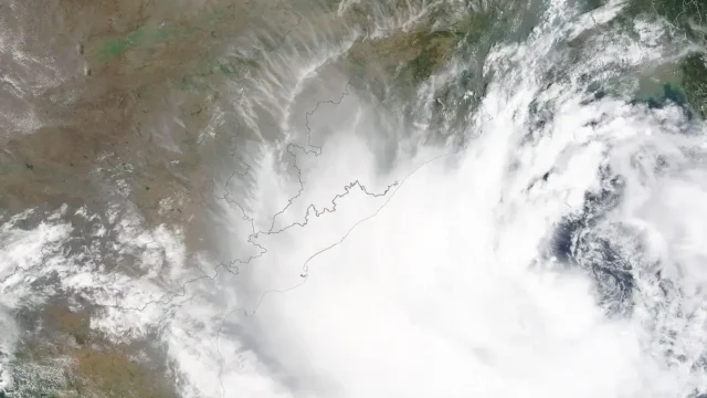
IMD launches a map-based Decision Support System for cyclone and marine warnings
On 12 October 2026 the India Meteorological Department dedicated a Cyclone Warning and Marine Weather Services Decision Support System to the nation. The WebGIS platform shows cyclone track, intensity, winds, rainfall, storm surge and district-wise warnings on one map for disaster managers and the public.
UPSC angle: Prelims: IMD, cone of uncertainty, storm surge. · Mains GS-III: early warning and disaster preparedness.
13 Oct 2026
New Doppler weather radars at Raipur and Mangaluru
Gaps in radar cover leave flash floods and thunderstorms unforecast.
UPSC angle: Prelims: Mission Mausam.
27 Nov 2025Learn the concept
Question text as printed in the official UPSC question paper: https://www.upsc.gov.in/sites/default/files/QP_CSM_2024_GenStud_I_03102024.pdf The model answer is original Battle IAS work; use it to learn structure, not to memorise.