
Cyclones: Formation of Tropical Cyclones, Structure, Classification, Naming, Temperate Cyclones and Cyclone Management in India (UPSC Notes + PYQs)
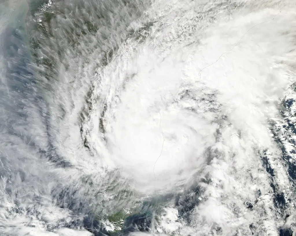
UPSC has already asked about this. Read the story with these questions in mind.
- Prelims 2020Consider the following statements: Jet streams occur in the Northern Hemisphere only. …Solve it below ↓
- Mains 2024 · GS1What is sea surface temperature rise? How does it affect the formation of tropical cyclones?See model answer →
See all 4 PYQs
Conditions for a tropical cyclone
- Large sea surface with temperature above about 26.5-27°C, to a depth of around 50 m.
- Coriolis force strong enough to start rotation, so cyclones rarely form within about 5° of the equator.
- Low vertical wind shear, so the storm can grow tall.
- A pre-existing weak low-pressure area or disturbance.
- Upper-level divergence that removes rising air.
- Moist mid-troposphere.
The South Atlantic and South-East Pacific rarely see tropical cyclones because their seas are cooler, as cold currents (Benguela, Humboldt) flow there, and wind shear is high. Mains 2024 asked how rising sea surface temperature affects cyclones: warmer seas give more energy, faster intensification and heavier rain.
- 1Warm sea heats and moistens the air
- 2Air rises; condensation releases latent heat
- 3Pressure falls; more air rushes in
- 4Coriolis force sets up rotation
- 5Eye and eyewall form; storm intensifies
- 6Landfall cuts off moisture; storm weakens
Structure
At the centre is the eye, 20-50 km across: calm, mostly clear, with the lowest pressure and air that sinks and warms, so the eye is warmer than its surroundings. Around it is the eyewall, a ring of tall clouds with the strongest winds and heaviest rain. Outer rain bands spiral inwards. Not every cyclone develops a clear eye; it forms when the storm is well organised.
IMD classification (North Indian Ocean)
| Category | Maximum sustained wind |
|---|---|
| Depression | 31-49 km/h |
| Deep depression | 50-61 km/h |
| Cyclonic storm | 62-88 km/h |
| Severe cyclonic storm | 89-117 km/h |
| Very severe cyclonic storm | 118-166 km/h |
| Extremely severe cyclonic storm | 167-221 km/h |
| Super cyclonic storm | 222 km/h and above |
A storm gets a name once it reaches cyclonic storm level.
Naming
The WMO/ESCAP Panel on Tropical Cyclones names storms in the North Indian Ocean. Its 13 members (Bangladesh, India, Iran, Maldives, Myanmar, Oman, Pakistan, Qatar, Saudi Arabia, Sri Lanka, Thailand, UAE, Yemen) contributed 13 names each to a list of 169 adopted in 2020. The IMD’s Regional Specialised Meteorological Centre in New Delhi assigns names in turn. Names are not reused. Elsewhere tropical cyclones are called hurricanes (Atlantic, East Pacific) and typhoons (North-West Pacific).
Temperate (extra-tropical) cyclones
These form in mid-latitudes (35°-65°) where cold polar air meets warm tropical air along a front (polar front theory of Bjerknes). They are larger, cover land and sea, move west to east with the westerlies, have no eye, and bring widespread, steady rain. Western disturbances, which give winter rain and snow to north-west India, are related low-pressure systems from the Mediterranean region.
- Forms over warm seas, 5°-30°
- Energy from latent heat
- Has a calm eye
- Moves east to west with trade winds
- Smaller, very intense
- Forms along fronts, 35°-65°
- Energy from contrasting air masses
- No eye
- Moves west to east with westerlies
- Larger, less intense
Bay of Bengal vs Arabian Sea
The Bay of Bengal gets several times more cyclones than the Arabian Sea: it is warmer, receives remnants of Pacific typhoons, has low salinity surface water that keeps heat near the surface, and its funnel shape and flat deltaic coast make storm surges deadly. But the Arabian Sea has warmed fast, and strong cyclones there (Tauktae 2021, Biparjoy 2023) have become more common. Peak seasons: May and October-December, around monsoon onset and withdrawal.
Impact and management in India
About 5,700 km of India’s 7,500 km coastline is exposed to cyclones and tsunamis. The deadliest threat is the storm surge, followed by flooding rain and wind. The 1999 Odisha super cyclone killed about 10,000 people; after early warning, shelters and drills, Phailin (2013) and Fani (2019) saw far fewer deaths though they were similar in strength. Tools: IMD’s warnings, Doppler radars, NCRMP (shelters, embankments, warning systems with World Bank support), mangrove belts (which reduced damage in parts of Odisha in 1999), coastal regulation, and the “zero casualty” approach of Odisha.
Why India now loses fewer lives
The Odisha super cyclone of 1999 killed nearly 10,000 people. When Cyclone Phailin struck the same coast in 2013, fewer than 50 died, and Fani (2019) caused a similar low toll despite its strength. The change came from better forecasts and better planning. IMD’s track forecasts are now accurate to within about 100 km three days ahead, helped by Doppler weather radars along the coast and satellites such as INSAT-3D. Odisha built hundreds of multipurpose cyclone shelters, trained local volunteers, and moved over a million people before Phailin. The National Cyclone Risk Mitigation Project, supported by the World Bank, funded shelters, evacuation roads, saline embankments and early warning systems in coastal States. The UN praised Odisha’s “zero casualty” approach as a model.
Climate change and Arabian Sea cyclones
The Arabian Sea has warmed faster than most oceans, and studies by IITM Pune and others link this to a rise in the number and duration of severe cyclones there since 2000. Tauktae (2021) and Biparjoy (2023) were among the strongest in recent memory on the west coast. Cyclones are also intensifying rapidly, jumping categories within a day, which shortens warning time. Coastal cities such as Mumbai, Surat and Kochi, long thought to be relatively safe, now need the shelter and warning systems the east coast has built. Mangroves, as the Sundarbans showed during Amphan (2020), reduce storm surge and must be protected.
PYQ trend
Prelims asked the eye and jet streams (2020) and why cyclones don’t form in the South Atlantic (2015). Mains asked sea surface temperature and cyclones (2024) and the Fujiwhara effect (2026), the interaction of two nearby cyclones that rotate around each other and may merge.
Cyclones: UPSC angle
For UPSC CSE
Prelims: conditions, structure, naming, regional names. Mains GS-I: formation and distribution; GS-III: disaster management and coastal resilience.
Cyclones UPSC PYQs (Prelims)
Questions UPSC has actually asked, from the official papers. Pick an option to check yourself.
Consider the following statements :
– 1. Jet streams occur in the Northern Hemisphere only.
– 2. Only some cyclones develop an eye.
– 3. The temperature inside the eye of a cyclone is nearly 10°C lesser than that of the surroundings.
Which of the statements given above is/are correct ?
Jet streams blow in both hemispheres. Only mature, strong tropical cyclones develop a clear eye, and temperate cyclones have none. Sinking air makes the eye warmer than its surroundings, by as much as 10 °C, not colder. Answer as per the official UPSC key · Battle IAS PYQ bankAnswer (c) & why
In the South Atlantic and South-Eastern Pacific regions in tropical latitudes, cyclone does not originate. What is the reason?
Tropical cyclones grow out of disturbances along the ITCZ. Over the South Atlantic and south-east Pacific, the ITCZ rarely moves south of the equator, and the cold Benguela and Humboldt currents and strong wind shear add to the problem. UPSC’s key gives the missing ITCZ as the reason. Answer as per the official UPSC key · Battle IAS PYQ bankAnswer (b) & why
Mains PYQs on this topic
Questions from the official UPSC Mains papers (2023-2026 in the Battle IAS Mains bank), newest first. Each links to a model answer.
- UPSC Mains 2026 · GS Paper I · Q4 · 10 marks
What is the Fujiwhara effect? Explain its impact on the movement and intensity of tropical cyclones.
- UPSC Mains 2024 · GS Paper I · Q4 · 10 marks
What is sea surface temperature rise? How does it affect the formation of tropical cyclones?
Quick quiz
Tropical cyclones do not form near the equator mainly because
Rotation cannot start.Answer (b)
Which category starts at 222 km/h in IMD’s scale?
Highest class.Answer (c)
Typhoons occur in the
Hurricanes in the Atlantic.Answer (b)
FAQs
Why is the eye calm?
Air sinks in the eye and warms, suppressing clouds; the strong winds circle around it in the eyewall.
Who names cyclones in the Bay of Bengal and Arabian Sea?
IMD’s RSMC New Delhi, from the list prepared by the WMO/ESCAP Panel.
What is a storm surge?
An abnormal rise of sea level pushed onto land by cyclone winds and low pressure; it causes most cyclone deaths.
Why does the Bay of Bengal get more cyclones?
Warmer, low-salinity surface water, remnants of Pacific systems and its shape.
What is the Fujiwhara effect?
Two cyclones close to each other rotating around a common centre, sometimes merging.
What is a western disturbance?
An extra-tropical low-pressure system from the Mediterranean that brings winter rain and snow to north-west India.
Spotted an error? Tell us. We correct within 48 hours.
Image: https://commons.wikimedia.org/wiki/File:Tropical_Cyclone_Michaung_(MODIS).jpg
How to use this in Mains
If asked: Why is India's east coast more cyclone-prone, and how has India improved its preparedness? (GS-I/III)
Quote: “About 5,700 km of India’s 7,500 km coastline is exposed to cyclones and tsunamis.”
Use it: A strong opening data point on exposure.
In the news
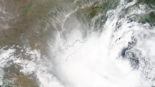
IMD launches a map-based Decision Support System for cyclone and marine warnings
On 12 October 2026 the India Meteorological Department dedicated a Cyclone Warning and Marine Weather Services Decision Support System to the nation. The WebGIS platform shows cyclone track, intensity, winds, rainfall, storm surge and district-wise warnings on one map for disaster managers and the public.
13 Oct 2026
India offers flood relief to Nepal; PM speaks to Nepal PM
On 26 August 2026 Prime Minister Narendra Modi spoke to Nepal's Prime Minister Balendra Shah and conveyed condolences on the loss of lives in floods in Nepal. He said India is ready to provide all possible humanitarian assistance, and that Indian teams are coordinating closely with Nepalese authorities on rescue and relief.
26 Aug 2026
UNCCD COP17: India urges shift from drought response to drought resilience
At a ministerial dialogue on drought resilience at UNCCD COP17 in Ulaanbaatar, Mongolia, on 25 August 2026, India called for a shift from reactive drought relief to proactive, technology-enabled resilience. The Environment Minister said drought must be managed as a predictable, preventable risk, with preparedness over response and prevention over crisis management.
25 Aug 2026
Urban Flood Risk Management Programme: Phase II in 11 cities incl. Lucknow and Kanpur
The Centre has approved the Urban Flood Risk Management Programme in two phases under the National Disaster Mitigation Fund, MHA told Lok Sabha on 11 August 2026. Phase I covers seven metros at ₹3075.65 crore. Phase II covers 11 cities, including Lucknow and Kanpur, at ₹2444.42 crore. States implement the projects.
11 Aug 2026