
Western Ghats: Extent, Formation, Rivers, Biodiversity Hotspot, Gadgil and Kasturirangan Reports and Conservation Issues (UPSC Notes + PYQs)
UPSC has already asked about this. Read the story with these questions in mind.
- Prelims 2016‘Gadgil Committee Report’ and ‘Kasturirangan Committee Report’, sometimes seen in the news, are related toSolve it below ↓
- Prelims 2017Consider the following statements: In India, the Himalayas are spread over five States only. …Solve it below ↓
See all 4 PYQs
- Prelims 2011Three of the following criteria have contributed to the recognition of Western Ghats-Sri Lanka and Indo-Burma regions as hotspots of biodiversitySolve it below ↓
- Prelims 2016In which of the following regions of India are you most likely to come across the ‘Great Indian Hornbill’ in its natural habitat?Solve it below ↓
Extent and formation
The Ghats pass through Gujarat, Maharashtra, Goa, Karnataka, Kerala and Tamil Nadu. They are not true mountains formed by folding; they are the raised, eroded western edge (escarpment) of the Peninsular plateau, thought to have formed when the western part of the landmass subsided into the Arabian Sea after India separated from Madagascar. Heights rise from north to south. The highest peak is Anamudi (2,695 m) in the Anaimalai hills of Kerala, the highest point in peninsular India; Doddabetta (2,637 m) in the Nilgiris is next. The Nilgiris are where the Western and Eastern Ghats meet.
Passes and gaps
- Thal Ghat and Bhor Ghat (Maharashtra): rail and road links from Mumbai to Nashik and Pune.
- Palghat (Palakkad) Gap: the widest break, linking Kerala and Tamil Nadu; it lets monsoon winds reach the interior and Coimbatore.
- Shencottah Gap: further south, between Kerala and Tamil Nadu.
Rivers and climate
The Ghats are the water tower of peninsular India. The Godavari (Trimbakeshwar), Krishna (Mahabaleshwar) and Kaveri (Talakaveri, Brahmagiri hills) rise here and flow east to the Bay of Bengal. Short, swift west-flowing rivers such as the Sharavathi (Jog Falls), Mandovi, Zuari and Periyar reach the Arabian Sea. The ranges block the south-west monsoon, causing heavy orographic rain on the windward side (Agumbe and Mahabaleshwar get several thousand millimetres) and a rain-shadow on the eastern side.
- Heavy orographic rain in June-September
- Tropical evergreen forests
- Short, swift west-flowing rivers
- Rain-shadow, much drier
- Moist and dry deciduous forests
- Long east-flowing rivers: Godavari, Krishna, Kaveri
Biodiversity
Though they cover under 6% of India’s land, the Ghats hold about 30% of its plant, fish, bird and mammal species. Endemism is very high: over a third of their flowering plants and most of their amphibians are found nowhere else. Signature species: lion-tailed macaque, Nilgiri tahr, Malabar large-spotted civet, purple frog, great hornbill, and the Neelakurinji shrub that flowers every 12 years. The Nilgiri Biosphere Reserve (1986) was India’s first; the Agasthyamala and Nilgiri reserves are in UNESCO’s network. Silent Valley (Kerala) was saved from a hydro project in the 1980s after a national campaign.
Gadgil vs Kasturirangan
| Point | Gadgil (WGEEP, 2011) | Kasturirangan (HLWG, 2013) |
|---|---|---|
| Area treated as sensitive | Whole Ghats (about 1.29 lakh sq km) in three Ecologically Sensitive Zones | About 37% (around 60,000 sq km) as Ecologically Sensitive Area |
| Basis | Ecology across the whole region | Separates “natural landscape” from “cultural landscape” (farms, settlements) |
| Mining and quarrying | Ban in ESZ-1 and ESZ-2 | Ban in ESA only |
| Decision-making | Bottom-up, Gram Sabhas and a Western Ghats Ecology Authority | Mostly existing regulatory system |
| Response | Opposed by States and some communities as too restrictive | Criticised by ecologists as too diluted |
The Centre has issued several draft notifications of the ESA since 2014 (the latest in 2024 covering about 56,800 sq km), but no final notification yet, as States seek to exclude villages.
Threats
- Quarrying, mining (Goa’s iron ore), and hydropower dams.
- Plantations replacing natural forest (tea, coffee, rubber, eucalyptus).
- Roads and railways fragmenting habitats.
- Landslides on deforested and cut slopes, worsened by extreme rain: Kerala floods (2018), Wayanad landslides (July 2024).
- Human-wildlife conflict with elephants and gaur.
- Invasive species like Lantana and Senna spectabilis.
- Steep slopes and thick weathered soil
- Extreme bursts of monsoon rain
- Quarrying and road cuts
- Loss of forest cover
- Plantations with shallow roots
Way forward
Finalise the ESA notification with Gram Sabha consultation; ban quarrying on steep, landslide-prone slopes; restore corridors such as those linking Nilgiris and the Eastern Ghats; landslide early warning in Kerala and Karnataka; and support communities through payment for ecosystem services and eco-tourism.
World Heritage status
In 2012 UNESCO inscribed 39 sites across Kerala, Karnataka, Tamil Nadu and Maharashtra as the Western Ghats World Heritage Site, as one of the world’s eight “hottest hotspots” of biodiversity. Kerala and Karnataka had objected that the listing could curb development. The sites include Silent Valley, Periyar, the Agasthyamalai hills, Kudremukh and Kaas plateau. India also lists the Nilgiri, Agasthyamalai and part of the Western Ghats under UNESCO’s Man and the Biosphere programme. In 2024 the Wayanad landslides renewed demands to notify the ecologically sensitive area recommended by the Kasturirangan report.
Endemic species to remember
The lion-tailed macaque, Nilgiri tahr, Malabar civet, purple frog and Malabar gliding frog are endemic to the Ghats, and the Neelakurinji shrub of the Nilgiris flowers once in twelve years.
PYQ trend
Prelims asked the hotspot criteria (2011), the Gadgil and Kasturirangan reports (2016), the States the Ghats cross (2017) and the great hornbill’s habitat (2016). Mains GS-I and GS-III bring them in through landslides, biodiversity and vegetation (2023).
Western Ghats: UPSC angle
For UPSC CSE
Prelims: States, peaks, passes, rivers, species, reports. Mains GS-I: physiography, landslides; GS-III: conservation vs development.
Western Ghats UPSC PYQs (Prelims)
Questions UPSC has actually asked, from the official papers. Pick an option to check yourself.
‘Gadgil Committee Report’ and ‘Kasturirangan Committee Report’, sometimes seen in the news, are related to
The Madhav Gadgil panel (2011) proposed making about 64% of the Western Ghats ecologically sensitive. The K. Kasturirangan group (2013) cut this to about 37% (about 60,000 sq km). The fight over eco-sensitive areas in the Ghats continues. Answer as per the official UPSC key · Battle IAS PYQ bankAnswer (d) & why
Consider the following statements :
– 1. In India, the Himalayas are spread over five States only.
– 2. Western Ghats are spread over five States only.
– 3. Pulicat Lake is spread over two States only.
Which of the statements given above is/are correct ?
The Indian Himalayas cross many states and UTs: J&K, Ladakh, Himachal, Uttarakhand, Sikkim, West Bengal, Arunachal and others. The Western Ghats run through six states: Gujarat, Maharashtra, Goa, Karnataka, Kerala and Tamil Nadu. Pulicat lagoon lies in Andhra Pradesh and Tamil Nadu only. Answer as per the official UPSC key · Battle IAS PYQ bankAnswer (b) & why
Three of the following criteria have contributed to the recognition of Western Ghats-Sri Lanka and Indo-Burma regions as hotspots of biodiversity :
– 1. Species richness
– 2. Vegetation density
– 3. Endemism
– 4. Ethno-botanical importance
– 5. Threat perception
– 6. Adaptation of flora and fauna to warm and humid conditions
Which three of the above are correct criteria in this context ?
A biodiversity hotspot (Norman Myers, Conservation International) must have at least 1,500 endemic plant species and must have lost at least 70% of its original habitat (threat). Rich species diversity is what makes these places count. Vegetation density and climate are not criteria. Answer as per the official UPSC key · Battle IAS PYQ bankAnswer (c) & why
In which of the following regions of India are you most likely to come across the ‘Great Indian Hornbill’ in its natural habitat?
The Great Hornbill needs tall evergreen and moist deciduous forest with big fruiting trees and nest holes. In India it lives in the Western Ghats and in the forests of the Northeast and the Himalayan foothills. The desert, high Himalaya and salt marshes have no such forest. Answer as per the official UPSC key · Battle IAS PYQ bankAnswer (d) & why
Mains PYQs on this topic
Questions from the official UPSC Mains papers (2023-2026 in the Battle IAS Mains bank), newest first. Each links to a model answer.
- UPSC Mains 2023 · GS Paper I · Q15 · 15 marks
Identify and discuss the factors responsible for diversity of natural vegetation in India. Assess the significance of wildlife sanctuaries in rain forest regions of India.
Quick quiz
How many States do the Western Ghats pass through?
Gujarat to Tamil Nadu.Answer (c)
The highest peak of the Western Ghats is
2,695 m.Answer (b)
The Kasturirangan report proposed treating about what share of the Ghats as an ESA?
Around 60,000 sq km.Answer (b)
FAQs
Are the Western Ghats fold mountains?
No. They are the uplifted, eroded western edge of the Peninsular plateau.
Why did States oppose the Gadgil report?
They felt treating the whole region as sensitive would stop development and affect farmers and settlements.
Which rivers rise in the Western Ghats?
Godavari, Krishna, Kaveri and many short west-flowing rivers.
What is the Palghat Gap?
A wide break in the Ghats between Kerala and Tamil Nadu that allows road, rail and monsoon winds through.
Why are the Western Ghats a hotspot?
High species richness and endemism with heavy loss of original habitat.
Spotted an error? Tell us. We correct within 48 hours.
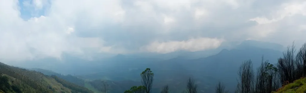
Image: DRUID1962, Wikimedia Commons, CC BY-SA 4.0
How to use this in Mains
If asked: Why is the Western Ghats both ecologically vital and vulnerable? Discuss. (GS-I/III)
Quote: “Palghat (Palakkad) Gap: the widest break, linking Kerala and Tamil Nadu; it lets monsoon winds reach the interior and Coimbatore.”
Use it: Use as a geography example showing how gaps shape climate and connectivity.
In the news
Five new Allographa lichen species found in the Western Ghats
Scientists from MACS Agharkar Research Institute, Pune (DST) reported five new species of Allographa lichens from the Western Ghats. Allographa is a script-lichen genus in Graphidaceae with more than 200 species. The work is the first comprehensive molecular phylogeny of Allographa from the Western Ghats.
21 Jul 2026
Mizoram University’s museum becomes India’s 21st designated biodiversity repository
MoEFCC designated the Natural History Museum, Mizoram University, Aizawl, as a Designated Repository under Section 39 of the Biological Diversity Act, 2002. The 19 June 2026 notification makes it India's 21st such repository. It will hold voucher and type specimens from the Indo-Burma Biodiversity Hotspot.
7 Jul 2026