
Chapter 2 · Topic 2.1 · Prelims + Mains1 of 4
Geomorphology: Interior and plates
Key points
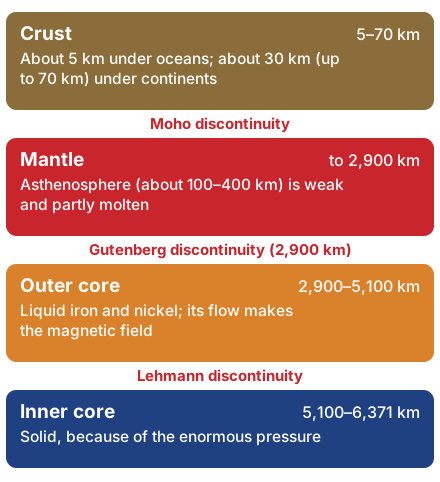
- Layers: crust, mantle (with the soft asthenosphere), liquid outer core, solid inner core. Boundaries: Moho, Gutenberg (2,900 km), Lehmann.
- How we know: mostly from earthquake waves. S-waves cannot pass the liquid outer core, which creates a shadow zone.
- Wegener's drift (1912): one supercontinent, Pangaea; evidence asked in Mains 2013 and Prelims 2025.
- Sea-floor spreading (Hess, 1961) and plate tectonics (1960s): about seven major plates; divergent, convergent and transform boundaries.
- Mantle plume (Mains 2018): hot rising rock that makes hotspots like Hawaii and Réunion; drift and glacial cycles shaped evolution (Prelims 2014).
Prelims box: facts and traps
- Sial and sima: continental crust is granitic (silica + aluminium); oceanic crust is basaltic (silica + magnesium).
- P-waves pass through solids, liquids and gases; S-waves only through solids.
- Shadow zone: no S-waves beyond about 105°; P-waves weak between about 105° and 145°.
- Prelims 2025 drift evidence: all three statements correct (c). Prelims 2014: both drift and glacial cycles (c).
Inside the Earth: crust, mantle and core
Like tapping a watermelon to check if it is ripe, scientists “listen” to the Earth through earthquake waves.
The deepest hole, Kola in Russia, reached only about 12 km. So we know the interior indirectly, from clues: volcanoes, meteorites, gravity, magnetism and, above all, earthquake waves. These waves change speed because the layers have different density, which means how tightly packed the material is.
| Layer | Depth | What to remember |
|---|---|---|
| Crust | About 5 km under oceans, about 30 km (up to 70 km under mountains) under continents | Oceanic crust is basaltic (silica and magnesium, ‘sima’); continental crust is granitic (silica and aluminium, ‘sial’) |
| Mantle | Moho to about 2,900 km | The asthenosphere (roughly 100–400 km) is weak and partly molten: the main source of magma, and the layer plates glide over |
| Outer core | 2,900 to about 5,100 km | Liquid iron and nickel; its flow makes the Earth’s magnetic field |
| Inner core | 5,100 km to the centre (6,371 km mean radius) | Solid, because of the enormous pressure |
Each boundary is a discontinuity, which means a sudden change in rock that makes waves change speed.
- Mohorovičić (Moho) discontinuity: between crust and mantle.
- Gutenberg discontinuity: between mantle and core, at 2,900 km.
- Lehmann discontinuity: between the outer and inner core.
The lithosphere means the crust plus the rigid top of the mantle, up to about 100 km thick. Below it lies the soft asthenosphere, on which the plates glide.
Earthquake waves are the vibrations sent out from the focus, the point inside the Earth where the quake starts.
| Earthquake wave | Moves through | Key fact |
|---|---|---|
| P (primary) | Solids, liquids and gases | Fastest; first to arrive; push-pull (longitudinal) |
| S (secondary) | Solids only | Side-to-side; they vanish at the outer core, which proves it is liquid |
| Surface waves | Along the surface | Arrive last; cause most of the damage |
Shadow zone. S-waves are not recorded beyond about 105° from the focus, and P-waves weaken between about 105° and 145°. This “silent” belt, called the shadow zone, is how seismologists found that the outer core is liquid.
Continental drift, sea-floor spreading and plate tectonics
Continental drift is the idea that continents move. In 1912 Alfred Wegener proposed that all continents once formed one supercontinent, Pangaea, surrounded by one ocean, Panthalassa. Pangaea split into Laurasia in the north and Gondwanaland in the south, and the pieces drifted apart.
Mains 2013 asked about this theory and its evidence:
- Jig-saw fit: South America and Africa fit like puzzle pieces.
- Matching rocks and mountain belts across the Atlantic.
- Same fossils: Mesosaurus and Glossopteris on continents now far apart.
- Tillite, which means old glacial deposits, in India, Africa and Australia, places that are warm today.
- Placer gold in Ghana: it has no source rock in Ghana but matches the Brazil plateau.
What do you understand by the theory of ‘continental drift’? Discuss the prominent evidences in its support.
Prelims 2025 asked which are evidences of drift: ancient rocks of the Brazil coast matching those of western Africa; Ghana’s gold coming from the Brazil plateau when the two lay side by side; and the Gondwana sediments of India having counterparts in six landmasses of the southern hemisphere. All three are correct (option c).
Wegener’s weak point was the force. He blamed the tidal force and a “pole-fleeing” force, both far too small, so the theory was rejected for decades.
Which of the following are the evidences of the phenomenon of continental drift? I. The belt of ancient rocks from Brazil coast matches with those from Western Africa. II. The gold deposits of Ghana are derived from the Brazil plateau when the two continents lay side by side. III. The Gondwana system of sediments from India is known to have its counterparts in six different landmasses of the Southern Hemisphere. Select the correct answer using the code given below.
- I and III only
- I and II only
- I, II and III
- II and III only
Show answer
Answer: (c) · UPSC official key
Finding the force (1930s–60s). Arthur Holmes suggested convection currents in the mantle: hot rock rises, cools and sinks, like water boiling in a pot. After the Second World War, maps of the ocean floor showed long underwater mountain chains called mid-ocean ridges. Harry Hess proposed sea-floor spreading (1961): magma rises at the ridge, makes new crust and pushes the old crust aside, like a conveyor belt. The proof:
- Rocks get older the farther they are from the ridge.
- Matching bands of magnetic stripes lie on both sides of the ridge.
- Sediments are thin near the ridge.
- No ocean floor is older than about 200 million years, while continental rocks reach about 4 billion years.
Plate tectonics (1960s) joined these ideas. The lithosphere is broken into about seven major and many minor plates, giant slabs that move a few centimetres a year, about as fast as your fingernails grow.
| Boundary | What happens | Examples |
|---|---|---|
| Divergent (constructive) | Plates move apart; new crust forms | Mid-Atlantic Ridge, Iceland; East African Rift on land |
| Convergent (destructive) | Plates meet; one sinks (subducts) or both crumple | Ocean–continent: Andes. Ocean– ocean: Japan, Mariana Trench. Continent–continent: Himalaya |
| Transform (conservative) | Plates slide past; crust is neither made nor destroyed | San Andreas Fault, California |
Mains 2025 asked how tectonic movements change the shape and size of continents and ocean basins. Oceans open at ridges (the Atlantic is still widening) and close at subduction zones, where one plate sinks under another (the Pacific is shrinking). Continents rift apart (East Africa) or collide and weld together (India and Eurasia).
Mains 2018 asked to define a mantle plume and explain its role. A mantle plume is a column of unusually hot rock rising from deep in the mantle. Where it reaches the surface it makes a hotspot, such as Hawaii or Réunion. A plate passing over a plume gets a chain of volcanoes; plumes can help start rifting; and the Réunion plume is linked to the Deccan Traps about 66 million years ago.
Discuss how the changes in shape and sizes of continents and ocean basins of the planet take place due to tectonic movements of the crustal masses.
Define mantle plume and explain its role in plate tectonics.
India’s own journey. The Indian plate broke from Gondwana, raced north (one of the fastest plate movements known) and began colliding with Asia about 50 million years ago. This raised the Himalaya, which are still rising.
Prelims 2014 asked which phenomena might have influenced the evolution of organisms: continental drift and glacial cycles. Both (option c): drift separated populations and changed climates, and ice ages forced species to adapt, migrate or die out.
Which of the following phenomena might have influenced the evolution of organisms? 1. Continental drift 2. Glacial cycles Select the correct answer using the code given below.
- 1 only
- 2 only
- Both 1 and 2
- Neither 1 nor 2
Show answer
Answer: (c) · UPSC official key
What UPSC asks: layers and discontinuities, P and S waves, drift evidence, boundary examples and mantle plumes. Next likely angle: ridges, trenches and hotspots on the map.
Mains box: analysis and answer points
- 2013: continental drift and its evidence. 2018: mantle plume and plate tectonics. 2025: how tectonics changes the shape and size of continents and oceans.
- Structure answers as: idea, evidence, mechanism, Indian example (Indian plate and the Himalaya).
Practice
Practice MCQs (8)
Which one of the following best brings out the basic difference between Wegener's continental drift theory and the theory of plate tectonics?
Answer (a) & explanation
NCERT stresses that 'it is not the continent that moves as believed by Wegener'; continents are part of a plate, and what moves is the plate. A tectonic plate is a rigid slab of lithosphere that usually has both continental and oceanic parts and moves over the asthenosphere. Plate tectonics does not deny Pangaea; it sees Pangaea as the result of earlier wandering continental masses coming together.
At which type of plate boundary is the crust neither produced nor destroyed, the plates simply sliding horizontally past each other?
Answer (d) & explanation
NCERT defines three kinds of plate boundary. At divergent boundaries new crust is generated as plates pull apart; at convergent boundaries crust is destroyed as one plate dives under another in a subduction zone; at transform boundaries the plates slide past each other and crust is neither produced nor destroyed. Transform faults generally run perpendicular to the mid-oceanic ridges and offset them.
Consider the following pairs: Feature — Type of plate boundary
1. Andes mountains — Ocean-continent convergence
2. Alpine Fault of New Zealand — Transform boundary
3. Iceland — Convergent boundary
4. Tonga Trench — Continent-continent convergence
How many of the pairs given above are correctly matched?
Answer (b) & explanation
Pairs 1 and 2 are correct, so two are matched. The Andes rise where the oceanic Nazca plate subducts beneath the South American plate, an ocean-continent convergence. The Alpine Fault of New Zealand's South Island is the transform boundary between the Australian and Pacific plates. Iceland sits astride the Mid-Atlantic Ridge, a divergent boundary (with a hotspot below it), and the Tonga Trench marks the subduction of one oceanic plate under another, an ocean-ocean convergence.
Consider the following statements about the continental drift theory:
1. Wegener named the supercontinent Pangaea and the mega-ocean surrounding it Panthalassa.
2. According to Wegener, Pangaea first broke into Laurasia in the north and Gondwanaland in the south.
3. Wegener, a German geologist, was the first person to suggest that the Americas, Europe and Africa were once joined together.
Which of the statements given above is/are correct?
Answer (d) & explanation
Statements 1 and 2 are correct. Wegener put forward his theory in 1912; he called the single landmass Pangaea ('all earth') and the ocean around it Panthalassa ('all water'), and held that Pangaea first split into Laurasia and Gondwanaland, which broke up further into today's continents. Statement 3 is wrong on two counts: Wegener was a meteorologist, and NCERT credits the Dutch map maker Abraham Ortelius (1596) with first proposing that the continents on either side of the Atlantic were once joined.
Consider the following statements: Statement-I: Most scientists of Wegener's time did not accept his theory of continental drift. Statement-II: The pole-fleeing and tidal forces that Wegener proposed were considered far too weak to move continents.
Which one of the following is correct in respect of the above statements?
Answer (a) & explanation
Both statements are correct and Statement-II explains Statement-I. Wegener offered strong evidence that the continents had once been joined, but his mechanism was weak: NCERT notes that most scholars considered the pole-fleeing force and the tidal force totally inadequate. The missing force was the main reason the theory was set aside, until Holmes proposed mantle convection and post-war ocean-floor studies revived the idea.
Consider the following statements about the ocean floor and the distribution of earthquakes:
1. Earthquakes along the mid-oceanic ridges generally have shallow foci.
2. Along deep ocean trenches, earthquake foci lie at progressively greater depths in an inclined zone that dips beneath the overriding plate.
3. Volcanic activity on the mid-oceanic ridges is concentrated on their flanks, while the rift at the crest is inactive.
Which of the statements given above is/are correct?
Answer (b) & explanation
Statements 1 and 2 are correct. NCERT notes that quake foci are shallow at the mid-oceanic ridges and deep-seated at the trenches; the deep quakes trace the sinking slab in an inclined band known as the Wadati-Benioff zone. Statement 3 is wrong: the rift system at the crest is the zone of intense volcanic activity, where new oceanic crust forms, and the mid- oceanic ridge system is the longest mountain chain on Earth though it lies under the sea.
Arrange the following ideas about the distribution of continents and oceans in the order in which they were put forward:
1. Convection currents in the mantle as the driving force, discussed by Arthur Holmes
2. The continental drift theory of Alfred Wegener
3. The hypothesis of sea-floor spreading by Harry Hess
4. The concept of plate tectonics by McKenzie and Parker, and by Morgan
Select the correct answer using the code given below.
Answer (b) & explanation
The correct order is 2-1-3-4. Wegener put forward continental drift in 1912; Holmes discussed mantle convection in the 1930s as a possible force; Hess (1961, as NCERT dates it) proposed sea-floor spreading after post-war mapping and palaeomagnetic studies of the ocean floor; and in 1967 McKenzie and Parker, and Morgan independently put the ideas together as plate tectonics.
With reference to attempts to drill into the Earth's interior, consider the following statements:
1. Project Mohole aimed to drill through the ocean floor to the Moho and was cancelled in 1966.
2. Drilling from the deep ocean floor is attractive for reaching the Moho because the oceanic crust is much thinner than the continental crust.
3. The Japanese drilling ship Chikyu, built for the Integrated Ocean Drilling Program, has already drilled through the Moho into the mantle.
Which of the statements given above is/are correct?
Answer (b) & explanation
Statements 1 and 2 are correct. Project Mohole of the early 1960s was a United States attempt to drill to the Moho from the deep ocean; after early success in deep-ocean drilling it ran into opposition and cost overruns and was cancelled in 1966. It inspired the later Deep Sea Drilling Project, the Ocean Drilling Program and the Integrated Ocean Drilling Program. The ocean floor is chosen because oceanic crust is only about 5 to 10 km thick, against roughly 30 km or more for continents. Statement 3 is wrong: Chikyu was built with the aim of reaching the mantle, but drilling to the Moho remains an unmet scientific objective; no hole has yet crossed it.
0 / 0 correct
Write an answer
In 150 words, explain the significance of Geomorphology with one recent example.
Flashcards (9)
Which earthquake waves cannot pass
through liquids? S-waves.
Depth of the mantle–core boundary?
About 2,900 km (Gutenberg discontinuity).
What is the asthenosphere?
The weak, partly molten upper mantle; source of magma.
Who proposed continental drift, and when?
Alfred Wegener, 1912.
Name the supercontinent and its ocean.
Pangaea and Panthalassa.
Who proposed sea-floor spreading?
Harry Hess (1961).
Give a transform boundary example.
San Andreas Fault.
What does a mantle plume create at the
surface? A hotspot, such as Hawaii or Réunion.
Did continental drift influence the evolution
of organisms (2014)? Yes; so did glacial cycles.
Read more: related explainers
In the news
- 25 Oct 2026Bleached corals revived in the lab: two studies on algae transfer and heat-tolerant symbionts
- 25 Oct 2026Niño 3.4 crosses 30°C for the first time: a possibly record El Niño and what it means for India
- 25 Oct 2026North India is drying: IMD–IITM study on shifting climate zones and the Pacific ‘Victoria Mode’
- 16 Oct 2026Neyveli, Tiruchirappalli and Atacama: Indian scientists identify Martian analogue sites
 Next topic · 2.2 →Geomorphology: Volcanoes, earthquakes and mountains
Syllabus: GS-I · Salient features of world’s physical geography.