
Chapter 6 · Topic 6.2 · Prelims + Mains2 of 3
World Geography: Seas, straits and regions
Key points
- Chokepoints: Hormuz (2026), Sumed (2024), Bosporus (Turkey, 2014), North Sea (2024);
- Regions: Levant (2022), Jordan (2015), Afghanistan's neighbours (2022), Ukraine's (2023),
Prelims box: facts and traps
- Others to know: the Spratly and Paracel Islands (South China Sea), the Kuril Islands (Russia–Japan) and the Chagos Archipelago, which the UK agreed in 2025 to hand to Mauritius.
- In Prelims 2025 the rows read 'I. Mallorca Italy II.
- (Bulgaria joined in 2026) India–EU trade talks
- ASEAN 11 South-East Asian states (Timor- Act East policy; Malacca
- Trap (UPSC Prelims 2014): all the statements are correct.
- Trap (UPSC Prelims 2026): “Belarus” is incorrect. “Switzerland” is incorrect.
Seas, straits, gulfs, islands and ports
A strait is a narrow sea passage between two larger bodies of water; an isthmus is a narrow neck of land joining two larger land areas (Panama, Suez). Most of the world’s trade goes by sea, and it must squeeze through a handful of these straits. They are called chokepoints, because blocking one can choke a supply chain.
Start with the seas around Europe. Prelims 2014 asked: Turkey is located between Prelims 2014 the Black Sea and the Mediterranean Sea (option b). Through Turkey run the Bosporus and the Dardanelles, the only link between the Black Sea and the open ocean. Prelims 2024 asked how many of Finland, Germany, Norway and Russia have a border with the North Sea: only two, Germany and Norway (option b). Finland and Russia sit on the Baltic.
Turkey is located between
- Black Sea and Caspian Sea
- Black Sea and Mediterranean Sea
- Gulf of Suez and Mediterranean Sea
- Gulf of Aqaba and Dead Sea
Show answer
Answer: (b) · UPSC official key
Consider the following countries : 1. Finland 2. Germany 3. Norway 4. Russia How many of the above countries have a border with the North Sea ?
- Only one
- Only two
- Only three
- All four
Show answer
Answer: (b) · UPSC official key
Prelims 2026 asked: Ships from which of the following countries have to cross the Strait of Hormuz to reach out to the Indian Ocean: Bahrain, Syria, Qatar and Egypt? Only Bahrain and Qatar (option b), as both lie wholly inside the Persian Gulf. Syria opens on the Mediterranean and Egypt on both the Mediterranean and the Red Sea. Kuwait and Iraq are also Gulf-locked; Saudi Arabia, the UAE and Oman have other coasts or pipelines. The 2026 answer is the provisional key; UPSC releases its official key after the whole exam.
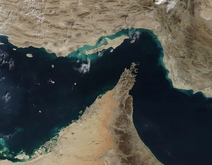
Ships from which of the following countries have to cross the Strait of Hormuz to reach out to the Indian Ocean ? 1. Bahrain 2. Syria 3. Qatar 4. Egypt Select the answer using the code given below :
- 1 and 2
- 1 and 3
- 2 and 3
- 3 and 4
Show answer
Answer: (b) · UPSC provisional key (final key awaited)
When ships want to skip the Suez Canal, oil can take a pipe. Prelims 2024 said that Sumed pipeline is a strategic route for Persian Gulf oil and natural gas shipments to Europe, and that it connects the Red Sea with the Mediterranean Sea. Both are correct, and the second explains the first (option a). It runs across Egypt from Ain Sukhna on the Gulf of Suez to Sidi Kerir near Alexandria, taking crude from tankers too big for the canal.
Consider the following statements : Statement-I : Sumed pipeline is a strategic route for Persian Gulf oil and natural gas shipments to Europe. Statement-II : Sumed pipeline connects the Red Sea with the Mediterranean Sea. Which one of the following is correct in respect of the above statements ?
- Both Statement-I and Statement-II are correct and Statement-II explains Statement-I
- Both Statement-I and Statement-II are correct, but Statement-II does not explain Statement-I
- Statement-I is correct, but Statement-II is incorrect
- Statement-I is incorrect, but Statement-II is correct
Show answer
Answer: (a) · UPSC official key
Mains 2022 asked: Mention the significance of straits and isthmus in international trade. Mains 2022 Shorter routes (Suez saves several thousand kilometres between Mumbai and London compared with going round Africa); cheaper freight and energy security; strategic leverage for the states on their shores; risk, because piracy, war or a single stuck ship (the Ever Given in Suez, March 2021) can halt trade. Canals cut through isthmuses at Suez and Panama. Mains 2016 said: South China Sea has assumed great geopolitical significance in the present context. Mains 2016 Comment. It sits between the Malacca Strait and East Asia, carries a large share of world shipping, holds fish, oil and gas, and is contested: China’s ‘nine-dash line’ claim was rejected by the arbitral tribunal under UNCLOS in 2016.
Mention the significance of straits and isthmus in international trade.
South China Sea has assumed great geopolitical significance in the present context. Comment.
Islands carry disputes too. Prelims 2022 asked which statement best reflects the issue with Senkaku Islands: China and Japan engage in maritime disputes over these islands in East China Sea (option b). Japan administers them; China and Taiwan claim them as Diaoyu. Others to know: the Spratly and Paracel Islands (South China Sea), the Kuril Islands (Russia–Japan) and the Chagos Archipelago, which the UK agreed in 2025 to hand to Mauritius.
Which one of the following statements best reflects the issue with Senkaku Islands, sometimes mentioned in the news ?
- It is generally believed that they are artificial islands made by a country around South China Sea.
- China and Japan engage in maritime disputes over these islands in East China Sea.
- A permanent American military base has been set up there to help Taiwan to increase its defence capabilities.
- Though International Court of Justice declared them as no man’s land, some South-East Asian countries claim them.
Show answer
Answer: (b) · UPSC official key
Mains 2026 asked candidates to examine: The centre of global trade is gradually shifting from the Atlantic region to the Indo-Pacific region. Mains 2026 For it: Asia’s share of world output and trade, the world’s busiest container ports (Shanghai, Singapore, Ningbo-Zhoushan, Shenzhen, Busan), and chains of production across China, ASEAN, India and Japan. Against it: the Atlantic still holds deep finance and technology, and Indo-Pacific routes rely on contested chokepoints. India gains as a hub through ports like Vizhinjam and Vadhavan and through the IMEC corridor plan.
“The centre of global trade is gradually shifting from the Atlantic region to the Indo-Pacific region.” Examine this statement.
Regions and neighbours in the news
UPSC loves the countries next to wherever the news is: a war, a canal, a new grouping. The trick is to learn regions as whole pictures, with neighbours, seas and capitals, not one country at a time.
Prelims 2022 asked: The term “Levant” often heard in the news roughly corresponds to Prelims 2022 the region along the eastern Mediterranean shores (option a). That covers Syria, Lebanon, Israel, Palestine and Jordan. Prelims 2015 asked which one of the following countries of South-West Asia does not open out to the Mediterranean Sea: Jordan (option b). Its only coast is a short stretch on the Gulf of Aqaba, at Aqaba port.
The term “Levant” often heard in the news roughly corresponds to which of the following regions ?
- Region along the eastern Mediterranean shores
- Region along North African shores stretching from Egypt to Morocco
- Region along Persian Gulf and Horn of Africa
- The entire coastal areas of Mediterranean Sea
Show answer
Answer: (a) · UPSC official key
Which one of the following countries of South-West Asia does not open out to the Mediterranean Sea?
- Syria
- Jordan
- Lebanon
- Israel
Show answer
Answer: (b) · UPSC official key
Prelims 2022 asked which of Azerbaijan, Kyrgyzstan, Tajikistan, Turkmenistan and Uzbekistan have borders with Afghanistan: Tajikistan, Turkmenistan and Uzbekistan (option c). Prelims 2023 asked how many of Bulgaria, the Czech Republic, Hungary, Latvia, Lithuania and Romania share a land border with Ukraine: only two, Hungary and Romania (option a).
Consider the following countries : 1. Azerbaijan 2. Kyrgyzstan 3. Tajikistan 4. Turkmenistan 5. Uzbekistan Which of the above have borders with Afghanistan ?
- 1, 2 and 5 only
- 1, 2, 3 and 4 only
- 3, 4 and 5 only
- 1, 2, 3, 4 and 5
Show answer
Answer: (c) · UPSC official key
Consider the following countries : 1. Bulgaria 2. Czech Republic 3. Hungary 4. Latvia 5. Lithuania 6. Romania How many of the above-mentioned countries share a land border with Ukraine?
- Only two
- Only three
- Only four
- Only five
Show answer
Answer: (a) · UPSC official key
Europe keeps coming back. In Prelims 2025 the rows read ‘I. Mallorca Italy II. Normandy Spain ‘ and ‘III. Sardinia France’. None is right (option d): Mallorca is Spanish, Normandy French and Sardinia Italian. Prelims 2026 asked which of Belarus, Poland, Germany and Switzerland are members of the European Union: Poland and Germany (option c, the provisional key). Switzerland and Norway stay out of the EU but are in the Schengen area; Belarus is Russia’s ally.
Consider the following pairs : Region Country I. Mallorca Italy II. Normandy Spain III. Sardinia France In how many of the above rows is the given information correctly matched?
- Only one
- Only two
- All the three
- None
Show answer
Answer: (d) · UPSC official key
Which of the following countries are members of the European Union ? 1. Belarus 2. Poland 3. Germany 4. Switzerland Select the answer using the code given below :
- 1, 2 and 4
- 1 and 4 only
- 2 and 3
- 2 and 4 only
Show answer
Answer: (c) · UPSC provisional key (final key awaited)
Sequence questions test latitude. Prelims 2014 asked: What is the correct sequence of occurrence of the following cities in SouthEast Asia as one proceeds from south to north? Prelims 2014 Jakarta (about 6° S), Singapore (1° N), Bangkok (14° N), Hanoi (21° N): 3-4-1-2 (option c).
What is the correct sequence of occurrence of the following cities in South-East Asia as one proceeds from south to north? 1. Bangkok 2. Hanoi 3. Jakarta 4. Singapore Select the correct answer using the code given below.
- 4-2-1-3
- 3-2-4-1
- 3-4-1-2
- 4-3-2-1
Show answer
Answer: (c) · UPSC official key
| Economic region or grouping | Members or core | Why it matters |
|---|---|---|
| European Union | 27 states; euro used by 21 (Bulgaria joined in 2026) | Largest single market; India–EU trade talks |
ASEAN 11 South-East Asian states (Timor- Act East policy; Malacca
Leste joined in October 2025) Strait
| Gulf Cooperation Council | Saudi Arabia, UAE, Qatar, Kuwait, Bahrain, Oman | Oil, remittances from millions of Indians |
|---|---|---|
| Industrial belts | North-eastern USA and the Great Lakes, the Ruhr, Pearl River Delta, Tokyo–Osaka | Classic and new manufacturing cores |
Mains box: analysis and answer points
- A strait is a narrow sea passage between two larger bodies of water; an isthmus is a narrow neck of land joining two larger land areas (Panama, Suez).
- Most of the world's trade goes by sea, and it must squeeze through a handful of these straits.
- Through Turkey run the Bosporus and the Dardanelles, the only link between the Black Sea and the open ocean.
- Only Bahrain and Qatar (option b), as both lie wholly inside the Persian Gulf.
- Likely next angle: Red Sea shipping, Hormuz, Chagos
- Asked: Mains 2022 (GS Paper I, 15 marks): Mention the significance of straits and isthmus in international trade.
Practice
Practice MCQs (8)
Which one of the following seas has no land coastline and is bounded entirely by ocean currents?
Answer (d) & explanation
The Sargasso Sea in the North Atlantic is the only sea without a land boundary. It is enclosed by a ring of currents of the North Atlantic Gyre: the Gulf Stream on the west, the North Atlantic Current on the north, the Canary Current on the east and the North Atlantic Equatorial Current on the south. Its calm, clear water is known for floating Sargassum seaweed and as the spawning ground of European and American eels.
The point where the Equator crosses the Prime Meridian (0° latitude, 0° longitude) lies in which one of the following water bodies?
Answer (d) & explanation
The intersection of the Equator and the Prime Meridian lies in the open Atlantic waters of the Gulf of Guinea, a few hundred kilometres south of the coast of Ghana. The Gulf of Aden lies near 12° N and 45° E, the Bay of Biscay off France and Spain near 45° N, and the Arabian Sea east of 50° E; none of them is near 0°, 0°.
Consider the following statements: Statement-I: The surface salinity of the Baltic Sea is much lower than that of the open ocean. Statement-II: The Baltic Sea receives a large inflow of river water and exchanges water with the North Sea only through narrow and shallow straits.
Which one of the following is correct in respect of the above statements?
Answer (a) & explanation
Both statements are correct and Statement-II explains Statement-I. Salinity depends on the balance between freshwater added (rain, rivers) and water removed (evaporation). The Baltic is a nearly enclosed sea fed by many rivers of Scandinavia, Finland, Russia, Poland and Germany; its cold climate keeps evaporation low, and the narrow Danish straits limit the inflow of salty North Sea water. NCERT notes that the Baltic records low salinity because of the influx of river water, while the Red Sea and the Persian Gulf are highly saline.
Which one of the following is NOT a marginal sea of the Pacific Ocean?
Answer (c) & explanation
The Weddell Sea is a large embayment of the Antarctic coast east of the Antarctic Peninsula, in the Southern Ocean (Atlantic sector); it is where much of the cold, dense Antarctic Bottom Water forms. The Sea of Okhotsk (between Kamchatka, Sakhalin and Hokkaido), the Coral Sea (off north-eastern Australia) and the Tasman Sea (between Australia and New Zealand) are all marginal seas of the Pacific.
Consider the following statements about the Dead Sea:
1. Its shoreline is the lowest land elevation on the Earth's surface.
2. The Jordan River is its main source of inflow.
3. It drains into the Gulf of Aqaba through a narrow outlet channel.
Which of the statements given above is/are correct?
Answer (a) & explanation
Statements 1 and 2 are correct. The Dead Sea lies in the Jordan Rift Valley between Jordan on the east and Israel and the West Bank on the west; its shore, about 430 metres below sea level, is the lowest exposed land on Earth. It is fed mainly by the Jordan River. It is a terminal (endorheic) lake with no outlet: water leaves only by evaporation, which is why its salinity is about ten times that of the ocean. The Gulf of Aqaba lies far to the south and is not connected to it.
The drastic shrinking of the Aral Sea since the 1960s is chiefly attributed to
Answer (b) & explanation
The Aral Sea, a terminal lake between Kazakhstan and Uzbekistan, was once the world's fourth-largest lake. From the 1960s the Soviet Union diverted its two feeder rivers, the Amu Darya and the Syr Darya, into canals to irrigate cotton, rice and other crops in the desert. With little water reaching it, the lake split into separate basins, its salinity rose sharply, and the exposed seabed (the Aralkum) now produces salt and dust storms.
Consider the following statements about the gulfs and bays around India:
1. The Gulf of Kachchh lies to the north of the Saurashtra (Kathiawar) peninsula.
2. The Gulf of Khambhat lies between the Saurashtra peninsula and mainland Gujarat.
3. The Gulf of Mannar lies between south-eastern India and western Sri Lanka.
4. Palk Bay lies to the south of Adam's Bridge (Rama Setu).
How many of the statements given above are correct?
Answer (c) & explanation
Statements 1, 2 and 3 are correct. Saurashtra is flanked by the Gulf of Kachchh on the north and the Gulf of Khambhat on the east, which separates it from mainland Gujarat. The Gulf of Mannar lies between Tamil Nadu and western Sri Lanka, south of the chain of shoals called Adam's Bridge (Rama Setu). Palk Bay lies to the north of Adam's Bridge and opens through the Palk Strait into the Bay of Bengal, so statement 4 reverses the order.
Consider the following statements about the channels around India's island groups:
1. The Duncan Passage separates the South Andaman group (Rutland Island) from Little Andaman.
2. The Nine Degree Channel separates Minicoy island from the main Lakshadweep group of islands.
3. The Coco Channel separates North Andaman from Little Andaman.
Which of the statements given above is/are correct?
Answer (a) & explanation
Statements 1 and 2 are correct. The Duncan Passage lies between Rutland Island off South Andaman and Little Andaman. The Nine Degree Channel separates Minicoy from the main Lakshadweep group (Kalpeni and the islands to the north), while the Eight Degree Channel separates Minicoy from the Maldives. The Coco Channel lies between North Andaman and the Coco Islands of Myanmar, not between North and Little Andaman, which are far apart with South and Middle Andaman in between.
0 / 0 correct
Write an answer
In 150 words, explain the significance of World Geography with one recent example.
Flashcards (8)
Turkey lies between which two seas?
Black Sea and Mediterranean Sea.
Which of Finland, Germany, Norway and
Russia touch the North Sea? Germany and Norway.
Which countries must cross Hormuz:
Bahrain, Syria, Qatar, Egypt? Bahrain and Qatar.
What does the Sumed pipeline connect?
The Red Sea (Gulf of Suez) and the Mediterranean.
Senkaku Islands dispute: who and where?
China and Japan, East China Sea.
Which Levant country has no
Mediterranean coast? Jordan.
Which Central Asian states border
Afghanistan? Tajikistan, Turkmenistan, Uzbekistan.
Which of Bulgaria, Czechia, Hungary,
Latvia, Lithuania, Romania border Ukraine? Hungary and Romania.
Read more: related explainers
In the news
- 25 Oct 2026Cauvery panel tells Karnataka to release 3,000 cusecs to Tamil Nadu: Article 262 and the inter-State water dispute
- 25 Oct 2026Bleached corals revived in the lab: two studies on algae transfer and heat-tolerant symbionts
- 25 Oct 2026Niño 3.4 crosses 30°C for the first time: a possibly record El Niño and what it means for India
- 25 Oct 2026Iran warns of an ‘apocalyptic war’ if attacked again: what it means for India, the Strait of Hormuz and BRICS
 Next topic · 6.3 →World Geography: World climate regions, vegetation and agriculture