
Chapter 7 · Topic 7.2 · Prelims + Mains2 of 3
Indian Physical Geography: Peninsula, coasts, islands and rivers
Key points
- Rivers: Indus system (2021), Sutlej (2026), Arunachal rivers (2014), Teesta (2017), glaciers and
Prelims box: facts and traps
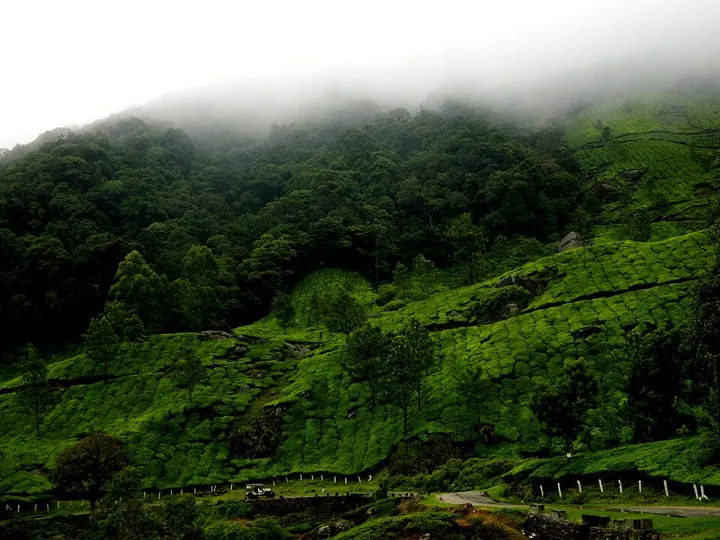
- Western Ghats (Sahyadri) Height Higher; Anaimudi (2,695 m) in the → Eastern Ghats Lower; peaks such as: Anaimalai hills is the highest peak of → Mahendragiri; peninsular India Rain and forests Very wet on the windward side; evergreen → Drier; deciduous forests; forests; a global biodiversity hotspot and → ; World Heritage Site Where Gujarat, Maharashtra, Goa, Karnataka, → Odisha, Andhra Pradesh,; Kerala, Tamil Nadu (six states) Forest and tea gardens on the Western Ghats near Munnar, Kerala. → Telangana, Tamil Nadu.
- Preparedness: INCOIS early warnings, IMD cyclone forecasts that cut deaths sharply (Odisha, since 1999), the National Cyclone Risk Mitigation Project, shelters and the Coastal Regulation Zone rules.
- The National Perspective Plan (1980) proposes 30 links: 14 in the Himalayan component and 16 in the peninsular.
- The first to start is the Ken–Betwa link in Bundelkhand, whose foundation stone was laid in December 2024.
- Trap (UPSC Prelims 2024): “Dhuandhar Malwa Narmada” is incorrect. “Hundru Chota Nagpur Subarnarekha” is incorrect. “Gersoppa Western Ghats Netravati In how many of the above rows is the given information correctly matched ?” is incorrect.
- Trap (UPSC Prelims 2021): “Brahmani” is incorrect. “Subarnarekha” is incorrect.
The peninsular plateau, coastal plains and islands
The peninsular plateau is a triangle of old, hard rock, bounded by the Aravallis in the north-west, the Rajmahal hills and Shillong plateau in the east, and the Western and Eastern Ghats on its sides. The Narmada rift splits it into the Central Highlands (Malwa, Bundelkhand, Baghelkhand, Chota Nagpur) to the north and the Deccan plateau to the south. It slopes east, which is why most peninsular rivers flow to the Bay of Bengal.
Hills are the heart of these questions. Prelims 2014 paired hills with regions, starting with Cardamom Hills Coromandel Coast and Kaimur Hills Konkan Coast, then Mahadeo Hills with Central India and Mikir Hills with North-East India. Only the last two are right (option c): the Cardamom Hills are in the southern Western Ghats and the Kaimur Hills are the eastern end of the Vindhyas.
Consider the following pairs : Hills Region 1. Cardamom Hills Coromandel Coast 2. Kaimur Hills Konkan Coast 3. Mahadeo Hills Central India 4. Mikir Hills North-East India Which of the above pairs are correctly matched?
- 1 and 2
- 2 and 3
- 3 and 4
- 2 and 4
Show answer
Answer: (c) · UPSC official key
Prelims 2015 matched pilgrim towns with hills: Srisailam Nallamala Hills 2. Omkareshwar Satmala Hills 3. Pushkar Mahadeo Hills. Only Srisailam–Nallamala is right (option a); Omkareshwar is on a Narmada island in the Vindhya–Satpura belt and Pushkar is in the Aravallis. Prelims 2023 said that Amarkantak Hills are at the confluence of Vindhya and Sahyadri Ranges, that the Biligirirangan Hills are the easternmost part of the Satpura, and that the Seshachalam Hills are the southern end of the Western Ghats. None is correct (option d): Amarkantak joins the Vindhya and Satpura (Maikal), the Biligirirangan Hills link the Western and Eastern Ghats, and the Seshachalam Hills (Tirupati) are part of the Eastern Ghats.
Consider the following pairs : Place of Pilgrimage Location 1. Srisailam Nallamala Hills 2. Omkareshwar Satmala Hills 3. Pushkar Mahadeo Hills Which of the above pairs is/are correctly matched?
- 1 only
- 2 and 3 only
- 1 and 3 only
- 1, 2 and 3
Show answer
Answer: (a) · UPSC official key
Consider the following statements : 1. Amarkantak Hills are at the confluence of Vindhya and Sahyadri Ranges. 2. Biligirirangan Hills constitute the easternmost part of Satpura Range. 3. Seshachalam Hills constitute the southernmost part of Western Ghats. How many of the statements given above are correct?
- Only one
- Only two
- All three
- None
Show answer
Answer: (d) · UPSC official key
Western Ghats (Sahyadri) Eastern Ghats
Continuity Continuous, broken only by passes (Thal, Broken into separate hills
Bhor, Pal) by the big east-flowing rivers
| Western Ghats (Sahyadri) Height Higher; Anaimudi (2,695 m) in the | Eastern Ghats Lower; peaks such as |
|---|---|
| Anaimalai hills is the highest peak of | Mahendragiri |
| peninsular India Rain and forests Very wet on the windward side; evergreen | Drier; deciduous forests |
| forests; a global biodiversity hotspot and | |
| World Heritage Site Where Gujarat, Maharashtra, Goa, Karnataka, | Odisha, Andhra Pradesh, |
| Kerala, Tamil Nadu (six states) Forest and tea gardens on the Western Ghats near Munnar, Kerala. | Telangana, Tamil Nadu |
The western coastal plain is narrow and drowned by the sea: Kachchh and Kathiawar, then the Konkan (Mumbai to Goa), Kanara and the Malabar coast with its lagoons (kayals) and backwaters. Its rivers make estuaries, not deltas, and it has natural harbours (Mumbai, Mormugao, Kochi). The eastern coastal plain is wider and built by deltas of the Mahanadi, Godavari, Krishna and Kaveri: the Northern Circars in the north and the Coromandel coast in the south, with lagoons such as Chilika and Pulicat.
Mains 2023 asked: Comment on the resource potentials of the long coastline of India and highlight the status of natural hazard preparedness in these areas. Mains 2023 The long-used figure for the coastline is 7,516.6 km; a recent remeasurement on finer maps put it at about 11,098 km. Resources: fisheries, ports and shipping (Sagarmala), offshore oil and gas (Mumbai High, Krishna–Godavari), placer minerals (monazite in Kerala sands), salt, tidal and offshore wind energy, mangroves, and tourism. Preparedness: INCOIS early warnings, IMD cyclone forecasts that cut deaths sharply (Odisha, since 1999), the National Cyclone Risk Mitigation Project, shelters and the Coastal Regulation Zone rules; gaps remain in coastal erosion, sea-level rise and urban flooding.
Comment on the resource potentials of the long coastline of India and highlight the status of natural hazard preparedness in these areas.
India has two groups of islands. The Andaman and Nicobar Islands in the Bay of Bengal are the peaks of a drowned mountain chain, an extension of Myanmar’s Arakan Yoma; Barren Island there is India’s only active volcano. Lakshadweep in the Arabian Sea is made of coral atolls. Prelims 2014 asked which one of the following pairs of islands is separated from each other by the ‘Ten Degree Channel’: Andaman and Nicobar (option a); it runs between Little Andaman and Car Nicobar. Prelims 2017 asked which of the following is geographically closest to Great Nicobar: Sumatra (option a), across the Great Channel. Indira Point on Great Nicobar is India’s southernmost point.
Which one of the following pairs of islands is separated from each other by the ‘Ten Degree Channel’?
- Andaman and Nicobar
- Nicobar and Sumatra
- Maldives and Lakshadweep
- Sumatra and Java
Show answer
Answer: (a) · UPSC official key
Which of the following is geographically closest to Great Nicobar ?
- Sumatra
- Borneo
- Java
- Sri Lanka
Show answer
Answer: (a) · UPSC official key
Rivers, lakes and waterfalls
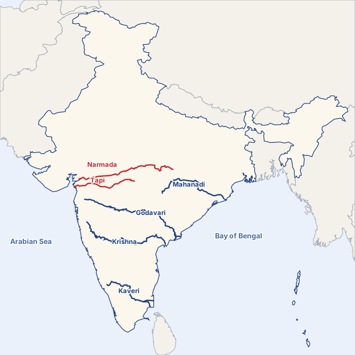
India’s rivers fall into two families: the Himalayan rivers, which flow all year, and the peninsular rivers, which depend on the monsoon. Most drain into the Bay of Bengal; the Narmada, Tapi, Mahi and Sabarmati drain into the Arabian Sea.
Prelims 2021 asked: With reference to the Indus river system, of the following four rivers, three of them pour into one of them which joins the Indus direct. That river is the Sutlej (option d): the Jhelum and Ravi join the Chenab, the Beas joins the Sutlej, and the Chenab and Sutlej together form the Panjnad, which meets the Indus near Mithankot in Pakistan. Prelims 2026 gave four clues. It has an antecedent drainage system. Prelims 2026 It flows through three countries, rises in the Tibetan Plateau and does not form distributaries. The river is the Sutlej (option c, provisional key), rising near Rakas Tal and cutting through the Himalaya at Shipki La.
With reference to the Indus river system, of the following four rivers, three of them pour into one of them which joins the Indus direct. Among the following, which one is such river that joins the Indus direct?
- Chenab
- Jhelum
- Ravi
- Sutlej
Show answer
Answer: (d) · UPSC official key
Identify the river of the Indian sub-continent on the basis of the following information : 1. It has an antecedent drainage system. 2. It flows through three countries. 3. It originates in the Tibetan Plateau and is an important river for irrigation. 4. It does not form distributaries. Select the answer from the following :
- Brahmaputra
- Indus
- Sutlej
- Teesta
Show answer
Answer: (c) · UPSC provisional key (final key awaited)
The north-east is a frequent target. Prelims 2014 listed the Barak, Lohit and Subansiri and asked: Which of the above flows/flow through Arunachal Pradesh? Prelims 2014 Lohit and Subansiri (option b); the Barak rises in Manipur and flows through Mizoram and Assam into Bangladesh. Prelims 2017 asked about the Teesta. The source of river Teesta is the same as that of Brahmaputra is wrong (it rises in north Sikkim); the Rangeet rising in Sikkim and joining it is right; and it does not reach the sea at the border but joins the Brahmaputra in Bangladesh. So 2 only (option b).
Consider the following rivers : 1. Barak 2. Lohit 3. Subansiri Which of the above flows/flow through Arunachal Pradesh?
- 1 only
- 2 and 3 only
- 1 and 3 only
- 1, 2 and 3
Show answer
Answer: (b) · UPSC official key
With reference to river Teesta, consider the following statements : 1. The source of river Teesta is the same as that of Brahmaputra but it flows through Sikkim. 2. River Rangeet originates in Sikkim and it is a tributary of river Teesta. 3. River Teesta flows into Bay of Bengal on the border of India and Bangladesh. Which of the statements given above is/are correct ?
- 1 and 3 only
- 2 only
- 2 and 3 only
- 1, 2 and 3
Show answer
Answer: (b) · UPSC official key
Glaciers and sources: Prelims 2019 paired glaciers with rivers, including Milam Mandakini 4. Siachen Nubra 5. Zemu Manas. Bandarpunch–Yamuna, Bara Shigri–Chenab and Siachen–Nubra are right (option a); Milam feeds the Goriganga and Zemu the Teesta. Prelims 2019 also paired pilgrim towns with rivers: Pandharpur Chandrabhaga 2. Tiruchirappalli Cauvery 3. Hampi Malaprabha. The first two are right (option a); Hampi stands on the Tungabhadra. Prelims 2021 listed the Brahmani, Nagavali, Subarnarekha and Vamsadhara and asked: Which of the above rise from the Eastern Ghats? Prelims 2021 Nagavali and Vamsadhara (option b); the other two rise on the Chota Nagpur plateau.
Consider the following pairs : Glacier River 1. Bandarpunch Yamuna 2. Bara Shigri Chenab 3. Milam Mandakini 4. Siachen Nubra 5. Zemu Manas Which of the pairs given above are correctly matched?
- 1, 2 and 4
- 1, 3 and 4
- 2 and 5
- 3 and 5
Show answer
Answer: (a) · UPSC official key
Consider the following pairs : Famous place River 1. Pandharpur Chandrabhaga 2. Tiruchirappalli Cauvery 3. Hampi Malaprabha Which of the pairs given above are correctly matched?
- 1 and 2 only
- 2 and 3 only
- 1 and 3 only
- 1, 2 and 3
Show answer
Answer: (a) · UPSC official key
Consider the following rivers : 1. Brahmani 2. Nagavali 3. Subarnarekha 4. Vamsadhara Which of the above rise from the Eastern Ghats?
- 1 and 2
- 2 and 4
- 3 and 4
- 1 and 3
Show answer
Answer: (b) · UPSC official key
| Lake | State | Type and fact |
|---|---|---|
| Wular | Jammu and Kashmir | Largest freshwater lake; on the Jhelum |
| Chilika | Odisha | Largest coastal lagoon (brackish); Irrawaddy dolphins; India’s first Ramsar site with Keoladeo (1981) |
| Sambhar | Rajasthan | Largest inland salt lake |
| Loktak | Manipur | Floating islands (phumdis); Keibul Lamjao, the only floating national park |
| Vembanad | Kerala | Longest lake; backwaters |
| Pulicat | Andhra Pradesh and Tamil Nadu | Second-largest lagoon; Sriharikota lies between it and the sea |
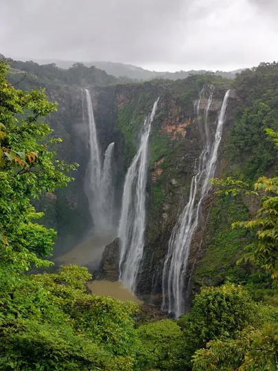
Waterfalls form where rivers drop off a plateau edge or a fault. Prelims 2024 gave waterfall, region and river: Dhuandhar Malwa Narmada 2. Hundru Chota Nagpur Subarnarekha 3. Gersoppa Western Ghats Netravati. Only one row is right (option a): Hundru. Dhuandhar on the Narmada is at Bhedaghat near Jabalpur, not in Malwa, and Gersoppa (Jog) is on the Sharavati, not the Netravati.
Consider the following information : Waterfall Region River 1. Dhuandhar Malwa Narmada 2. Hundru Chota Nagpur Subarnarekha 3. Gersoppa Western Ghats Netravati In how many of the above rows is the given information correctly matched ?
- Only one
- Only two
- All three
- None
Show answer
Answer: (a) · UPSC official key
Mains 2020 said: The interlinking of rivers can provide viable solutions to the multi-dimensional inter-related problems of droughts, floods, and interrupted navigation. Mains 2020 Critically examine. The National Perspective Plan (1980) proposes 30 links: 14 in the Himalayan component and 16 in the peninsular. The first to start is the Ken–Betwa link in Bundelkhand, whose foundation stone was laid in December 2024. Gains: water moved from surplus to deficit basins, irrigation, hydropower, inland navigation. Costs: huge expense, submergence of forests (part of Panna Tiger Reserve), displacement, changed river ecology and sediment flows to deltas, and disputes between states. Smaller steps such as watershed works and better irrigation efficiency often give more for less.
The interlinking of rivers can provide viable solutions to the multi-dimensional inter-related problems of droughts, floods, and interrupted navigation. Critically examine.
Mains box: analysis and answer points
- The peninsular plateau is a triangle of old, hard rock, bounded by the Aravallis in the north-west, the Rajmahal hills and Shillong plateau in the east, and the Western and Eastern Ghats on its sides.
- The Narmada rift splits it into the Central Highlands (Malwa, Bundelkhand, Baghelkhand, Chota Nagpur) to the north and the Deccan plateau to the south.
- Only the last two are right (option c): the Cardamom Hills are in the southern Western Ghats and the Kaimur Hills are the eastern end of the Vindhyas.
- Likely next angle: Great Nicobar project; new coastline figure
- Asked: Mains 2023 (GS Paper I, 15 marks): Comment on the resource potentials of the long coastline of India and highlight the status of natural hazard preparedness in these areas.
Practice
Practice MCQs (8)
The Godavari, the largest Peninsular river system and often called the 'Dakshin Ganga', rises in which district?
Answer (a) & explanation
The Godavari rises on the slopes of the Western Ghats near Trimbakeshwar in Nashik district of Maharashtra and flows about 1,465 km to the Bay of Bengal. Its basin (about 3.13 lakh sq km) is the largest of the Peninsula, hence the name Dakshin Ganga. Mahabaleshwar is the source of the Krishna, Brahmagiri of the Kaveri, and Amarkantak of the Narmada and the Son.
Which one of the following rivers does NOT drain into the Arabian Sea?
Answer (c) & explanation
The Penganga rises in the Ajanta range of Maharashtra and joins the Wardha, which flows into the Godavari and so reaches the Bay of Bengal. The Sabarmati and the Mahi reach the Arabian Sea through the Gulf of Khambhat, and the Periyar reaches it near Kochi.
The Jog (Gersoppa) falls, among the highest plunge waterfalls of India, are formed by which river?
Answer (a) & explanation
The Jog or Gersoppa falls in Shivamogga district of Karnataka are formed by the Sharavati, a west-flowing river that plunges about 250 m over the Western Ghats scarp and reaches the sea near Honnavar. The Netravati flows to Mangaluru, the Kali to Karwar and the Mandovi to Panaji.
Consider the following statements about the Kaveri:
1. Its upper catchment receives rain from the south-west monsoon and its lower catchment from the north-east monsoon.
2. As a result, its flow fluctuates less across the year than that of other large Peninsular rivers.
3. The largest share of its basin lies in Karnataka.
Which of the statements given above are correct?
Answer (b) & explanation
Statements 1 and 2 are correct. NCERT notes that the Kaveri's upper catchment (Karnataka, Kerala) gets south-west monsoon rain in summer and its lower catchment (Tamil Nadu) gets north-east monsoon rain in winter, so the river carries water almost all year with less fluctuation. Statement 3 is wrong: about 56% of the basin is in Tamil Nadu, 41% in Karnataka and 3% in Kerala.
Consider the following statements about the Peninsular Plateau:
1. It rises from about 150 m above the river plains to an elevation of 600–900 m.
2. Most of its major rivers flow eastwards, reflecting a general slope towards the Bay of Bengal.
3. Black soil is found mainly in its eastern part, along the Eastern Ghats.
4. In shape it is a regular rectangle bounded by straight fault lines.
How many of the statements given above are correct?
Answer (b) & explanation
Only two statements are correct. NCERT Class XI describes the Peninsular Plateau as an irregular triangle rising from about 150 m above the river plains to 600–900 m, and notes that the flow of its rivers shows its general slope; most major rivers (Mahanadi, Godavari, Krishna, Kaveri) flow east to the Bay of Bengal. Statement 3 is wrong: NCERT says the western and north-western part of the plateau has an emphatic presence of black soil. Statement 4 is wrong because the plateau is an irregular triangle, not a regular rectangle.
Which one of the following rivers rises near Ranchi and flows through Jharkhand, West Bengal and Odisha before entering the Bay of Bengal?
Answer (c) & explanation
The Subarnarekha rises near Nagri, south-west of Ranchi, forms the Hundru falls on the plateau edge, crosses Jharkhand, touches West Bengal and enters the sea in Balasore district of Odisha. The Damodar ends in the Hugli, while the Brahmani and Baitarani are Odisha rivers that build the delta with the Mahanadi.
Consider the following statements: Statement-I: The Mahanadi, Godavari, Krishna and Kaveri form large deltas on the east coast. Statement-II: These rivers flow down the gentle eastward slope of the Peninsula over long courses and bring large sediment loads to the shallow Bay of Bengal coast.
Answer (a) & explanation
Both are correct and II explains I. The east-flowing Peninsular rivers have long courses across the gently tilted plateau, collect large sediment loads from big basins and slow down on the flat eastern coastal plain, building deltas. By contrast the Narmada and Tapi flow fast through rift valleys and form estuaries on the west coast.
Consider the following statements about the Narmada:
1. It rises on the Amarkantak plateau.
2. It flows through a rift valley between the Vindhyan range to the north and the Satpura range to the south.
3. It builds a large delta where it meets the Arabian Sea.
Which of the statements given above are correct?
Answer (a) & explanation
Statements 1 and 2 are correct. The Narmada rises on the western flank of the Amarkantak plateau and flows west through a rift valley between the Vindhyas and the Satpuras, forming the Marble Rocks gorge and the Dhuandhar falls near Jabalpur. Statement 3 is wrong: it enters the Gulf of Khambhat through a wide estuary near Bharuch, not a delta.
0 / 0 correct
Write an answer
In 150 words, explain the significance of Indian Physical Geography with one recent example.
Flashcards (7)
Highest peak of peninsular India?
Anaimudi (2,695 m).
Amarkantak joins which two ranges?
Vindhya and Satpura (Maikal).
The Ten Degree Channel separates?
Little Andaman and Car Nicobar.
Closest foreign land to Great Nicobar?
Sumatra.
Which tributary joins the Indus directly?
Sutlej (as the Panjnad, with the Chenab).
Which of Brahmani, Nagavali,
Subarnarekha, Vamsadhara rise in the Eastern Ghats? Nagavali and Vamsadhara.
Hampi stands on which river?
Tungabhadra.
Read more: related explainers
In the news
- 25 Oct 2026Cauvery panel tells Karnataka to release 3,000 cusecs to Tamil Nadu: Article 262 and the inter-State water dispute
- 25 Oct 2026Bleached corals revived in the lab: two studies on algae transfer and heat-tolerant symbionts
- 25 Oct 2026Niño 3.4 crosses 30°C for the first time: a possibly record El Niño and what it means for India
- 25 Oct 2026Iran warns of an ‘apocalyptic war’ if attacked again: what it means for India, the Strait of Hormuz and BRICS
 Next topic · 7.3 →Indian Physical Geography: Soils, climate and the monsoon