
Chapter 7 · Topic 7.1 · Prelims + Mains1 of 3
Indian Physical Geography: Structure, Himalaya, plains and desert
Key points
- Location and extremes (2015); three geological parts; rock systems; Deccan Trap resources
- Himalaya: ranges, divisions, peaks (2022), plants (2014), states (2017), glacier melt (2020).
- Plains: bhabar, terai, bhangar, khadar; lower Ganga crops (2011); Ganga basin population
- Peninsula and hills (2014, 2015, 2023); Western vs Eastern Ghats; coasts and their resources
Prelims box: facts and traps
| Rock system | Age and rock |
|---|---|
| Archaean | Oldest; gneiss and granite |
| Dharwar | Metamorphosed sediments |
| Cuddapah and Vindhyan | Sandstone, limestone, shale |
| Gondwana | River deposits in rift valleys (Damodar, Mahanadi, Godavari) |
| Deccan Traps | Basalt lava flows of the late Cretaceous, about 66 million years ago |
| Tertiary and Quaternary | Young rocks of the Himalaya; alluvium of the plains. |
- divisions India lies wholly in the northern and eastern hemispheres, between about 8°4′ N and 37°6′ N and 68°7′ E and 97°25′ E. It covers about 3.28 million sq km, 2.4% of the world's land, and holds about a sixth of its people.
- 1,100 persons per sq km by the 2011 Census) because of deep khadar soils, flat land, perennial rivers and groundwater, and an old history of settled farming.
- The Tropic of Cancer (23°30′ N) cuts it almost in half and passes through eight states: Gujarat, Rajasthan, Madhya Pradesh, Chhattisgarh, Jharkhand, West Bengal, Tripura and Mizoram.
- Trap (UPSC Prelims 2017): “In India, the Himalayas are spread over five States only” is incorrect. “Western Ghats are spread over five States only” is incorrect.
- Trap (UPSC Prelims 2014): “Sandalwood” is incorrect.
On this page (3 sections)
India’s location, geology and physiographic
divisions India lies wholly in the northern and eastern hemispheres, between about 8°4′ N and 37°6′ N and 68°7′ E and 97°25′ E. It covers about 3.28 million sq km, 2.4% of the world’s land, and holds about a sixth of its people. The Tropic of Cancer (23°30′ N) cuts it almost in half and passes through eight states: Gujarat, Rajasthan, Madhya Pradesh, Chhattisgarh, Jharkhand, West Bengal, Tripura and Mizoram. Indian Standard Time is set on 82°30′ E, which passes near Mirzapur.
The east–west spread of about 30° of longitude means a two-hour gap in sunrise between Arunachal and Gujarat. Prelims 2015 asked which one of the following pairs of States of India indicates the easternmost and westernmost State: Arunachal Pradesh and Gujarat (option d).
Which one of the following pairs of States of India indicates the easternmost and westernmost State?
- Assam and Rajasthan
- Arunachal Pradesh and Rajasthan
- Assam and Gujarat
- Arunachal Pradesh and Gujarat
Show answer
Answer: (d) · UPSC official key
Geologists see three Indias. The Peninsula is a block of the ancient Gondwana land, among the oldest and most stable rock on Earth. The Himalaya and the north-east hills are young fold mountains, pushed up as the Indian plate drove into Asia. Between them, the Indo-Gangetic plain is a trough filled with river silt. From these come six physiographic divisions: the Himalaya, the northern plains, the peninsular plateau, the Indian desert, the coastal plains and the islands.
| Rock system | Age and rock | Economic value |
|---|---|---|
| Archaean | Oldest; gneiss and granite | Base of the peninsula |
| Dharwar | Metamorphosed sediments | Iron ore, manganese, gold (Kolar, Hutti); the most valuable metal-bearing rocks |
| Cuddapah and Vindhyan | Sandstone, limestone, shale | Building stone, cement limestone, Panna diamonds |
| Gondwana | River deposits in rift valleys (Damodar, Mahanadi, Godavari) | About 98% of India’s coal |
| Deccan Traps | Basalt lava flows of the late Cretaceous, about 66 million years ago | Black soil, building stone |
| Tertiary and Quaternary | Young rocks of the Himalaya; alluvium of the plains | Assam and Gujarat oil; the fertile plains |
Mains 2022 asked: Discuss the natural resource potentials of ‘Deccan Trap’. Mains 2022 Its basalt weathers into black cotton soil, which holds moisture and suits cotton, soybean and sugarcane. Its rock is a strong building stone. Laterite caps on the plateau hold bauxite (Kolhapur, Amarkantak). Its rivers drop over steps to give hydropower (Koyna). Cave-cut heritage (Ajanta, Ellora, Elephanta) brings tourism. The limits: groundwater is held only in cracks, so wells run dry, and the black soil cracks and erodes when bare.
Discuss the natural resource potentials of ‘Deccan Trap’.
The Himalaya
The Himalaya run in an arc about 2,400 km long from the Indus in the west to the Brahmaputra in the east. They are widest in Kashmir (about 400 km) and narrowest in Arunachal (about 160 km). They block cold Central Asian winds, catch the monsoon, feed perennial rivers with snow and glaciers, and hold forests, minerals, hydropower and pilgrim sites.
Prelims 2022 paired peaks with ranges: Namcha Barwa Garhwal Himalaya 2. Nanda Devi Kumaon Himalaya 3. Nokrek Sikkim Himalaya. Only Nanda Devi–Kumaon is right (option b). Namcha Barwa marks the eastern end of the Himalaya, where the Tsangpo bends round it; Nokrek is the highest peak of the Garo Hills in Meghalaya, and a biosphere reserve.
Consider the following pairs : Peak Mountains 1. Namcha Barwa Garhwal Himalaya 2. Nanda Devi Kumaon Himalaya 3. Nokrek Sikkim Himalaya Which of the pairs given above is/are correctly matched ?
- 1 and 2
- 2 only
- 1 and 3
- 3 only
Show answer
Answer: (b) · UPSC official key
Height decides vegetation. Prelims 2014 asked: If you travel through the Himalayas, you are likely to see which of the following plants naturally growing there? Oak and rhododendron, yes; sandalwood, no, because it grows in the dry deciduous forests of Karnataka and Tamil Nadu (option a). Going up: tropical sal forests in the foothills, then oak and chestnut, then deodar, pine, spruce and fir, then birch and rhododendron, then alpine meadows (bugyals in Uttarakhand, margs in Kashmir).
If you travel through the Himalayas, you are likely to see which of the following plants naturally growing there? 1. Oak 2. Rhododendron 3. Sandalwood Select the correct answer using the code given below.
- 1 and 2 only
- 3 only
- 1 and 3 only
- 1, 2 and 3
Show answer
Answer: (a) · UPSC official key
Prelims 2017 said: In India, the Himalayas are spread over five States only. That is wrong: they cover the UTs of Ladakh and Jammu and Kashmir and the states of Himachal Pradesh, Uttarakhand, Sikkim, West Bengal (Darjeeling) and Arunachal Pradesh, with the Purvachal hills in the north-east. The same question said that Pulicat Lake is spread over two States only, which is right (Andhra Pradesh and Tamil Nadu), and that the Western Ghats cover five states, which is wrong (six). So the answer was 3 only (option b).
Consider the following statements : 1. In India, the Himalayas are spread over five States only. 2. Western Ghats are spread over five States only. 3. Pulicat Lake is spread over two States only. Which of the statements given above is/are correct ?
- 1 and 2 only
- 3 only
- 2 and 3 only
- 1 and 3 only
Show answer
Answer: (b) · UPSC official key
Mains 2020 asked: How will the melting of Himalayan glaciers have a far-reaching impact on the water resources of India? Mains 2020 In the short run, more melt means floods and glacial lake outburst floods (Kedarnath 2013, South Lhonak in Sikkim 2023). In the long run, less ice means less summer flow in the Indus, Ganga and Brahmaputra, just when crops and cities need it most. That hurts irrigation, hydropower, drinking water, groundwater recharge in the plains, and river-sharing with neighbours.
How will the melting of Himalayan glaciers have a far-reaching impact on the water resources of India?
The northern plains and the Indian desert
The northern plains, about 7 lakh sq km, were built by the Indus, Ganga and Brahmaputra and their tributaries, dropping silt into the trough in front of the Himalaya. They are flat (the land falls only about 200 m from Delhi to the Bay of Bengal), fertile and well watered. They are among the most densely populated farmlands on Earth.
Rainfall and crops change from west to east. Prelims 2011 said: The lower Gangetic plain is characterised by humid climate with high temperature throughout the year. The best pair of crops there is paddy and jute (option c). Westward, the Punjab–Haryana plain is drier and grows wheat with canal and tube-well irrigation.
The lower Gangetic plain is characterised by humid climate with high temperature throughout the year. Which one among the following pairs of crops is most suitable for this region ?
- Paddy and cotton
- Wheat and Jute
- Paddy and Jute
- Wheat and cotton
Show answer
Answer: (c) · UPSC official key
Mains 2025 asked: Discuss the distribution and density of population in the Ganga River Basin with special reference to land, soil and water resources. Mains 2025 Density is very high (Bihar has over
1,100 persons per sq km by the 2011 Census) because of deep khadar soils, flat land, perennial rivers and groundwater, and an old history of settled farming. It thins out at the edges: in the Shiwalik and Terai belt, in the Chambal ravines and on the drier south-western margins. Pressure shows in tiny landholdings, falling water tables, floods in north Bihar and migration out.
Discuss the distribution and density of population in the Ganga River Basin with special reference to land, soil and water resources.
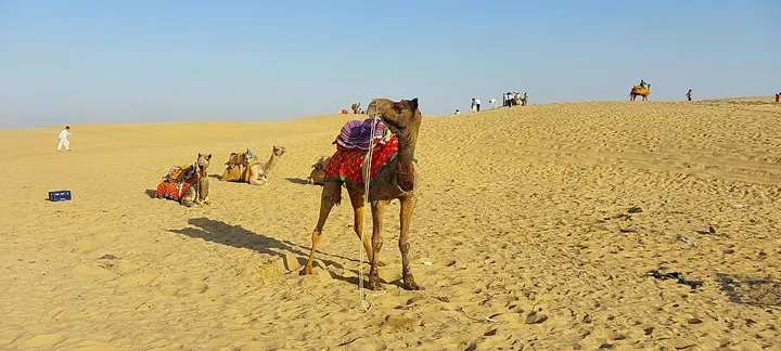
The Indian desert (Thar) lies west of the Aravallis, with under 15 cm of rain in the far west. It was under the sea in the Mesozoic era. It has sand dunes (barchans), few rivers (the Luni is the main one, ending in the Rann of Kutch) and salt lakes.
Prelims 2021 asked: With reference to India, Didwana, Kuchaman, Sargol and Khatu are the names of Prelims 2021 saline lakes (option d), in Rajasthan’s inland drainage, like the much bigger Sambhar, India’s largest inland salt lake.
With reference to India, Didwana, Kuchaman, Sargol and Khatu are the names of
- glaciers
- mangrove areas
- Ramsar sites
- saline lakes
Show answer
Answer: (d) · UPSC official key
Mains box: analysis and answer points
- The limits: groundwater is held only in cracks, so wells run dry, and the black soil cracks and erodes when bare.
- Oak and rhododendron, yes; sandalwood, no, because it grows in the dry deciduous forests of Karnataka and Tamil Nadu (option a).
- Likely next angle: Tropic of Cancer states; standard meridian
- Asked: Mains 2022 (GS Paper I, 10 marks): Discuss the natural resource potentials of ‘Deccan Trap’.
- Asked: Mains 2020 (GS Paper I, 10 marks): How will the melting of Himalayan glaciers have a far-reaching impact on the water resources of India?
Practice
Practice MCQs (8)
Consider the following statements about the belts of the Northern Plains:
1. The Bhabar is a narrow pebble-studded belt along the foot of the Shiwaliks in which most streams disappear.
2. The Terai lies to the north of the Bhabar, between the Bhabar and the Shiwaliks.
3. The Khadar consists of newer alluvium of the flood plains that is renewed almost every year.
Which of the statements given above is/are correct?
Answer (c) & explanation
Statements 1 and 3 are correct. Rivers descending from the mountains drop pebbles and boulders in a narrow belt parallel to the Shiwalik slopes called the Bhabar, and the streams disappear in it. South of the Bhabar the streams re-emerge and create the wet, swampy and marshy Terai, so statement 2 has the order wrong. Of the alluvial plains, the older alluvium is the Bhangar, while the newer flood-plain deposits that are renewed almost every year are the Khadar, which makes it fertile and ideal for intensive agriculture.
In the Northern Plains, the soil of the older alluvial tracts that lie above the flood plains contains calcareous deposits known locally as 'kankar'. These older alluvial tracts are called
Answer (b) & explanation
NCERT Class IX says the largest part of the Northern Plain is formed of older alluvium, which lies above the flood plains of the rivers and presents a terrace-like feature; this part is the Bhangar, and its soil contains calcareous deposits known locally as kankar. The Khadar is the newer alluvium of the flood plains, the Terai is the marshy belt south of the Bhabar, and the Bhabar is the pebble belt at the Shiwalik foot.
Consider the following statements about the geological divisions of India:
1. On the basis of geological structure and formations, India can be divided into the Peninsular Block, the Himalayas and other Peninsular mountains, and the Indo-Ganga-Brahmaputra Plain.
2. The Peninsular Block is formed essentially of a great complex of very ancient gneisses and granites.
3. Unlike the Peninsular Block, the Himalayas are rigid and stable in their geological structure.
Which of the statements given above is/are correct?
Answer (a) & explanation
Statements 1 and 2 are correct. NCERT Class XI divides India into three geological divisions: the Peninsular Block, the Himalayas and other Peninsular mountains, and the Indo- Ganga-Brahmaputra Plain. The Peninsula is made essentially of very ancient gneisses and granites and has stood like a rigid block since the Cambrian period. Statement 3 reverses the textbook: the Himalayas are young, weak and flexible in structure, which is why folds, faults and thrusts still develop there, while it is the Peninsular Block that is rigid and stable.
Consider the following statements about the regional divisions of the Northern Plain:
1. The Punjab plains are formed by the Indus and its tributaries, and a larger part of these plains lies in Pakistan.
2. The Ganga plain extends between the Ghaggar and the Teesta rivers.
3. The Brahmaputra plain lies mostly in West Bengal.
Which of the statements given above is/are correct?
Answer (d) & explanation
Statements 1 and 2 are correct. NCERT Class IX divides the Northern Plain into three sections. The western part, the Punjab plains, is formed by the Indus and its tributaries, and a larger part of it lies in Pakistan. The Ganga plain extends between the Ghaggar and the Teesta and spreads over the northern states of Haryana, Delhi, Uttar Pradesh, Bihar, part of Jharkhand and West Bengal. Statement 3 is wrong: the Brahmaputra plain to the east of the Teesta lies particularly in Assam.
According to NCERT, the water divide between the Indus and the Ganga river systems across the Northern Plains is formed by
Answer (d) & explanation
NCERT Class XI states that the states of Haryana and Delhi form a water divide between the Indus and the Ganga river systems. The divide is a slight rise within an otherwise featureless plain with a general elevation of about 50–150 m above mean sea level; streams to its west drain to the Indus system, while the Yamuna to its east drains to the Ganga.
Consider the following landforms:
1. Ox-bow lakes
2. Meanders
3. Gorges
4. V-shaped valleys
How many of the above are described by NCERT as characteristic features of the Bhangar and Khadar plains of northern India?
Answer (b) & explanation
Only two. NCERT Class XI says the Bhangar and Khadar plains show the characteristic features of the mature stage of fluvial erosional and depositional landforms, such as sand bars, meanders, ox-bow lakes and braided channels. Gorges and V-shaped valleys belong to the youthful stage of rivers in the mountains; NCERT mentions them as features of the Himalaya.
The Punjab plains are dominated by doabs, the tracts of land between two rivers. Consider the following pairs: Doab — Rivers between which it lies
1. Bist-Jalandhar Doab — Beas and Satluj
2. Bari Doab — Beas and Ravi
3. Rechna Doab — Chenab and Jhelum
4. Sind Sagar Doab — Ravi and Chenab
How many of the pairs given above are correctly matched?
Answer (b) & explanation
Only two pairs are correct. NCERT Class IX explains that 'doab' comes from do (two) and ab (water) and that the Punjab plains are dominated by doabs. The Bist-Jalandhar Doab lies between the Beas and the Satluj, and the Bari Doab between the Beas and the Ravi; both lie largely in Indian Punjab. The Rechna Doab lies between the Ravi and the Chenab, so pair 3 is wrong; the land between the Chenab and the Jhelum is the Chaj Doab. The Sind Sagar Doab lies between the Jhelum–Chenab and the Indus, so pair 4 is wrong.
In the drier parts of the Bhangar tracts of Punjab, Haryana and Uttar Pradesh, the terms 'reh' and 'kallar' refer to
Answer (c) & explanation
Regional geography texts such as Khullar describe reh, kallar or thur as saline and alkaline efflorescences that appear on the surface in the drier parts of the Bhangar, where capillary action brings salts up and leaves a white crust that makes the land unfit for crops. The other options are distinct local terms: the seasonal torrents of the Punjab Shiwalik foothills are the chos, and the sandy ridges along the Ganga in western Uttar Pradesh are called bhur.
0 / 0 correct
Write an answer
In 150 words, explain the significance of Indian Physical Geography with one recent example.
Flashcards (12)
Easternmost and westernmost states?
Arunachal Pradesh and Gujarat.
Which rocks hold about 98% of India's
coal? Gondwana.
Which rocks hold India's best iron ore and
gold? Dharwar.
Nanda Devi is in which division of the
Himalaya? Kumaon Himalaya.
Nokrek is the highest peak of?
The Garo Hills, Meghalaya.
Which does not grow naturally in the
Himalaya: oak, rhododendron, sandalwood? Sandalwood.
Flat valleys like Dehradun are called?
Duns.
Belt where streams re-emerge as marshy
land? Terai.
Best crops for the lower Gangetic plain?
Paddy and jute.
Didwana, Kuchaman, Sargol, Khatu are?
Saline lakes in Rajasthan.
Jog Falls is on which river?
Sharavati.
Which way does rainfall decrease in the
northern plains? From east to west.
Read more: related explainers
In the news
- 22 Oct 2026Haryana’s first private power distributor: what a parallel licence means for Gurugram and Nuh
- 21 Oct 2026Rubio at Jamnagar: US pitches oil and Venezuelan crude to India’s ‘refining superpower’
- 19 Oct 2026Pumped storage hydropower: India’s roadmap for 100 GW of ‘water batteries’ by 2035-36
- 17 Oct 2026Khet Bachao Abhiyan: Centre reviews 22 October to 30 November farm campaign with States
 Next topic · 7.2 →Indian Physical Geography: Peninsula, coasts, islands and rivers