
Chapter 6 · Topic 6.1 · Prelims + Mains1 of 3
Space Technology: ISRO, orbits, launchers and navigation
Key points
- Reforms, IN-SPACe, Space Policy 2023, orbits.
- PSLV, GSLV, LVM3, SSLV.
- NavIC, GAGAN, GPS timing.
- Remote sensing and NISAR.
- Chandrayaan-3, MOM, Chandrayaan-4.
Prelims box: facts and traps
| Orbit | Height |
|---|---|
| Geostationary (GEO) | 35,786 km above the equator |
| Polar / sun-synchronous | about 200 to 1,000 km |
| NISAR (example) | 747 km SSO |
| PSLV rating orbit | 600 km SSPO. |
- SSLV, the Small Satellite Launch Vehicle, made its third developmental flight on 16 August 2024, placing EOS-08 (about 175.5 kg) in a 475 km low Earth orbit at 37.4 degrees.
- IRNSS, renamed NavIC in 2016, is India's regional navigation system; it covers India and a region extending about 1,500 km around it, and was designed with 7 satellites (ISRO IRNSS page; GPS.gov).
- Reference stations on the ground monitor GPS signals; a master control centre computes corrections and integrity alerts, which are uplinked and broadcast through GAGAN payloads on GSAT-8, GSAT-10 and GSAT-15 (PIB, April 2022).
- Trap (UPSC Prelims 2018): all the statements are correct.
- Trap (UPSC Prelims 2018, the Indian Regional Navigation Satellite System (IRNSS)): “IRNSS covers entire India and about 5500 sq. km beyond its borders” is incorrect. “India will have its own satellite navigation system with full global coverage by the middle of 2019” is incorrect.
On this page (3 sections)
ISRO, space reforms and orbits
The Government of India unleashed reforms in the space domain in 2020, opening the doors for non-government entities (NGEs) to carry out end-to-end activities in the space domain on a level playing field. The Indian Space Policy 2023 is the overarching framework for these reforms. Under it, ISRO focuses on applied research and development of newer systems (space infrastructure, space transportation, applications, capacity building and human spaceflight), shares technologies with NGEs and enables open data access from remote sensing satellites; NewSpace India Limited (NSIL) is the Government company named in the policy (Indian Space Policy 2023, Department of Space).
IN-SPACe (Indian National Space Promotion and Authorisation Centre) is an autonomous Government organisation mandated to promote, hand-hold, guide and authorise space activities, and to act as the single window agency for authorising space activities (Indian Space Policy 2023). ISRO describes it as a single-window, independent, nodal agency in the Department of Space (ISRO, IN-SPACe page). So UPSC accepted that IN-SPACe is an autonomous agency formed to facilitate participation of private entities; the key also accepts the Agnikul Cosmos 3D-printed engine statement and rejects the claim about Skyroot and GSLV fuel (Prelims 2026: answer (c), 1 and 2 only; answer key provisional).
Consider the following statements with regard to involvement of private entities in India’s space programme : 1. The Indian National Space Promotion and Authorisation Centre (IN-SPACe) is an autonomous agency formed to facilitate participation of private entities. 2. Agnikul Cosmos launched the world’s first flight using 3D-printed rocket engine. 3. Skyroot Aerospace has developed liquid fuel for GSLV. Which of the statements given above is/are correct ?
- 1 only
- 2 and 3 only
- 1 and 2 only
- 1, 2 and 3
Show answer
Answer: (c) · UPSC provisional key (final key awaited)
A geostationary orbit lies above the Earth’s equator; the satellite moves from west to east, once every 23 hours 56 minutes 4 seconds, matching the Earth’s rotation, so it seems fixed in the sky. It is circular and sits 35,786 km above the surface, which is why it is used for telecommunication and weather satellites (European Space Agency, Types of orbits). So the orbit is geosynchronous, circular and The orbit lies in the plane of the equator; 22,236 is the height in miles, not km (Prelims 2011: answer (a), 1, 2 and 3 only).
Satellites used for telecommunication relay are kept in a geostationary orbit. A satellite is said to be in such an orbit when : 1. The orbit is geosynchronous. 2. The orbit is circular. 3. The orbit lies in the plane of the Earth’s equator. 4. The orbit is at an altitude of 22,236 km. Select the correct answer using the codes given below :
- 1, 2 and 3 only
- 1, 3 and 4 only
- 2 and 4 only
- 1, 2, 3 and 4
Show answer
Answer: (a) · UPSC official key
Low orbits serve other jobs. Polar orbits run roughly north-south, usually 200 to 1,000 km up; a sun-synchronous orbit (SSO) is a polar orbit timed so a satellite passes over each place at the same local solar time, which suits Earth observation. A geostationary transfer orbit (GTO) is the elliptical orbit into which rockets drop satellites bound for geostationary orbit (European Space Agency).
| Orbit | Height | Typical use | Source |
|---|---|---|---|
| Geostationary (GEO) | 35,786 km above the equator | Telecommunication, weather | ESA |
| Polar / sun-synchronous | about 200 to 1,000 km | Earth observation | ESA |
| NISAR (example) | 747 km SSO | Radar Earth observation | PIB, 30 Jul 2025 |
| PSLV rating orbit | 600 km SSPO | Payload rating (1,750 kg) | ISRO |
Heights are design or reference values from the sources named.
Mains 2016 asked: Discuss India’s achievements in the field of Space Science and Technology and how they helped socio-economic development. Points: reliable launchers (PSLV, GSLV, LVM3), NavIC and GAGAN for navigation and aviation, remote sensing for crops and water, the Mars Orbiter Mission, Chandrayaan-3’s landing near the lunar south pole, Aditya-L1 and NISAR (all covered on later pages), and the 2020 reforms that opened the sector to private firms.
Discuss India’s achievements in the field of Space Science and Technology. How the application of this technology has helped India in its socio-economic development?
Launch vehicles: PSLV, GSLV, LVM3 and SSLV
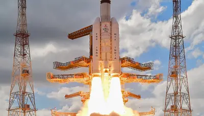
PSLV, the Polar Satellite Launch Vehicle, has four stages: the solid PS1 (S139, HTPB), the liquid PS2 with the Vikas engine, the solid PS3, and a PS4 with two liquid engines. It first flew on 20 September 1993 and had its first successful launch in October 1994. ISRO calls it its workhorse: it can carry 1,750 kg to a 600 km sun-synchronous polar orbit and 1,425 kg to a sub-geosynchronous transfer orbit, and it launched the IRNSS navigation satellites. PSLV-C37 carried 104 satellites in one flight (ISRO, PSLV page).
GSLV Mk II has three stages and four liquid strap-ons. Its upper stage is the Cryogenic Upper Stage, powered by the CE-7.5, India’s first cryogenic engine, burning liquid oxygen and liquid hydrogen; the indigenous stage flew from GSLV-D5 in January 2014. It lifts 2,250 kg to GTO and is meant for INSAT-class communication satellites (ISRO, GSLV page). LVM3 (Geosynchronous Satellite Launch Vehicle Mk III) has three stages: two S200 solid strap-ons, the L110 liquid core stage and the C25 cryogenic stage; it lifts 4,000 kg to GTO and 8,000 kg to low Earth orbit (ISRO, LVM3 page).
So PSLVs launch the satellites useful for Earth resources monitoring whereas GSLVs are designed mainly to launch communication satellites (true). Satellites launched by PSLV go mainly to polar orbits, so they do not stay fixed in the sky, and GSLV Mk III has three stages, not four (Prelims 2018: answer (a), 1 only).
With reference to India’s satellite launch vehicles, consider the following statements : 1. PSLVs launch the satellites useful for Earth resources monitoring whereas GSLVs are designed mainly to launch communication satellites. 2. Satellites launched by PSLV appear to remain permanently fixed in the same position in the sky, as viewed from a particular location on Earth. 3. GSLV Mk III is a four-staged launch vehicle with the first and third stages using solid rocket motors; and the second and fourth stages using liquid rocket engines. Which of the statements given above is/are correct ?
- 1 only
- 2 and 3
- 1 and 2
- 3 only
Show answer
Answer: (a) · UPSC official key
SSLV, the Small Satellite Launch Vehicle, made its third developmental flight on 16 August 2024, placing EOS-08 (about 175.5 kg) in a 475 km low Earth orbit at 37.4 degrees. This completed the SSLV
Development Project and opens the way for operational missions by Indian industry and NSIL (ISRO, SSLV-D3; PIB, PRID 2045802).
| Vehicle | Stages | Lift-off mass | Payload (rated) |
|---|---|---|---|
| PSLV | 4 (solid, liquid, solid, liquid) | 320 t | 1,750 kg to 600 km SSPO |
| GSLV Mk II | 3 + 4 liquid strap-ons | 420 t | 2,250 kg to GTO |
| LVM3 | 3 (S200 x2, L110, C25) | 640 t | 4,000 kg GTO; 8,000 kg LEO |
| SSLV | not stated here | not stated here | EOS-08, 175.5 kg to 475 km (D3 flight result) |
Source: ISRO vehicle pages; SSLV row from PIB, PRID 2045802. Payloads are rated capacities, not a single flight, except SSLV.
Navigation satellites: NavIC and GAGAN
IRNSS, renamed NavIC in 2016, is India’s regional navigation system; it covers India and a region extending about 1,500 km around it, and was designed with 7 satellites (ISRO IRNSS page; GPS.gov). It offers a Standard Positioning Service for all users and an encrypted Restricted Service, with position accuracy better than 20 m in the primary service area (ISRO). The constellation combines geostationary and inclined geosynchronous satellites; UPSC’s key rejects the statement that IRNSS covers entire India and about 5500 sq. km beyond (its range is 1,500 km), and India never planned global coverage by 2019 (Prelims 2018: answer (a), 1 only).
With reference to the Indian Regional Navigation Satellite System (IRNSS), consider the following statements : 1. IRNSS has three satellites in geostationary and four satellites in geosynchronous orbits. 2. IRNSS covers entire India and about 5500 sq. km beyond its borders. 3. India will have its own satellite navigation system with full global coverage by the middle of 2019. Which of the statements given above is/are correct ?
- 1 only
- 1 and 2 only
- 2 and 3 only
- None
Show answer
Answer: (a) · UPSC official key
Status in 2026: eleven NavIC satellites have been launched, eight are functional, three broadcast navigation signals and five can broadcast one-way messaging signals (PIB, 25 Mar 2026). A receiver needs at least four satellites for a standalone position, so standalone positioning is not available with three, though the timing service works (Lok Sabha reply, 2026).
| NavIC fact | Value | Status |
|---|---|---|
| Satellites launched | 11 | measured (PIB, 25 Mar 2026) |
| Functional satellites | 8 | measured (PIB, 25 Mar 2026) |
| Broadcasting navigation signals | 3 | measured (PIB, 25 Mar 2026) |
| Minimum for standalone position | 4 | technical requirement (Lok Sabha reply) |
| Coverage | India + 1,500 km | design (ISRO) |
NavIC status as reported to Parliament in 2026.
Other countries run regional systems too: QZSS is a regional GNSS owned by the Government of Japan that complements GPS in East Asia and Oceania; the global systems are GPS (USA), GLONASS (Russia), BeiDou (China) and Galileo (EU) (GPS.gov, Other GNSS). So Japan is the one with its own Satellite Navigation System (Prelims 2023: answer (d)).
Which one of the following countries has its own Satellite Navigation System?
- Australia
- Canada
- Israel
- Japan
Show answer
Answer: (d) · UPSC official key
GAGAN is a satellite-based augmentation system built jointly by the Airports Authority of India and ISRO. Certified by DGCA in 2015, it is one of only four such systems, with WAAS (USA), EGNOS (Europe) and
MSAS (Japan) (PIB, PRID 1820947). It augments GPS for accuracy, integrity and continuity, with benefits in aviation and non-aviation sectors (PIB, 8 Dec 2022). So it provides additional accuracy and integrity and better air traffic management, but statement III (aviation only) is wrong (Prelims 2025: answer (d), I and II only).
GPS-Aided Geo Augmented Navigation (GAGAN) uses a system of ground stations to provide necessary augmentation. Which of the following statements is/are correct in respect of GAGAN? I. It is designed to provide additional accuracy and integrity. II. It will allow more uniform and high quality air traffic management. III. It will provide benefits only in aviation but not in other modes of transportation. Select the correct answer using the code given below.
- I, II and III
- II and III only
- I only
- I and II only
Show answer
Answer: (d) · UPSC official key
GPS also gives time: it provides precise synchronisation of communications systems, power grids, financial networks and other critical infrastructure, and helps wireless networks use radio spectrum efficiently (GPS.gov, GPS and Telling Time). So mobile phone operations, banking and Controlling the power grids all use GPS (Prelims 2018: answer (d), 1, 2 and 3).
In which of the following areas can GPS technology be used ? 1. Mobile phone operations 2. Banking operations 3. Controlling the power grids Select the correct answer using the code given below :
- 1 only
- 2 and 3 only
- 1 and 3 only
- 1, 2 and 3
Show answer
Answer: (d) · UPSC official key
Mains 2018 asked: Why is Indian Regional Navigational Satellite System (IRNSS) needed? Mains 2018 Mains 2015 asked about Standard Positioning Systems and Precision Positioning Systems and the advantages of IRNSS with just seven satellites. Points: SPS is open to all; the precise, encrypted service (RS) is for authorised users; a regional system under national control avoids dependence on foreign systems in a crisis, and only a few satellites are needed because the coverage area is regional (ISRO; GPS.gov).
Why is Indian Regional Navigational Satellite System (IRNSS) needed? How does it help in navigation?
What do you understand by ‘Standard Positioning Systems’ and ‘Precision Positioning Systems’ in the GPS era? Discuss the advantages India perceives from its ambitious IRNSS programme employing just seven satellites.
Mains box: analysis and answer points
- The Government of India unleashed reforms in the space domain in 2020, opening the doors for non-government entities (NGEs) to carry out end-to-end activities in the space domain on a level playing field.
- The Indian Space Policy 2023 is the overarching framework for these reforms.
- ISRO describes it as a single-window, independent, nodal agency in the Department of Space (ISRO, IN-SPACe page).
- Likely next angle: SSO for Earth watch
- Asked: Mains 2016 (GS Paper III, 12.5 marks): Discuss India’s achievements in the field of Space Science and Technology. How the application of this technology has helped India in its socio-economic development?
Practice
Practice MCQs (8)
Consider the following satellite navigation systems:
1. Galileo
2. BeiDou
3. QZSS
4. NavIC
How many of the above are designed to provide global coverage?
Answer (b) & explanation
Two of them are global. Galileo (European Union) and BeiDou (China; the BeiDou-3 global system was formally commissioned on 31 July 2020) are global navigation satellite systems, along with GPS (USA) and GLONASS (Russia). QZSS (Michibiki, Japan) and NavIC (India) are regional systems: QZSS uses quasi-zenith orbits to keep a satellite high over Japan and serves the Asia-Oceania region, while NavIC covers India and about 1,500 km around it.
Consider the following launch vehicles:
1. PSLV
2. GSLV Mk II
3. LVM3
4. SSLV
How many of the above use a cryogenic stage?
Answer (b) & explanation
Only two use a cryogenic stage. The GSLV Mk II has the Cryogenic Upper Stage with the CE-7.5 engine, and LVM3 has the C25 stage with the CE-20 engine. Both need a cryogenic stage because they place heavy communication and navigation satellites in geosynchronous transfer orbit, where high-efficiency upper stages pay off. PSLV uses solid and storable-liquid stages, and SSLV uses solid stages with a small liquid trimming module.
With reference to NavIC (Navigation with Indian Constellation), consider the following statements:
1. Its first-generation satellites broadcast civilian signals in the L5 and S bands, and the second- generation NVS satellites add a signal in the L1 band.
2. NVS-01, launched in May 2023, was the first NavIC satellite to fly an indigenous atomic clock.
3. NavIC has been designed to provide positioning service over the whole globe, like GPS.
Which of the statements given above is/are correct?
Answer (a) & explanation
Statements 1 and 2 are correct. ISRO states that NavIC's Standard Positioning Service is provided in the L5 (1176.45 MHz) and S bands, and that NavIC satellites from 2023 onwards also broadcast in the L1 band (1575.42 MHz), the band used by most phone chips, which helps interoperability with GPS and Galileo. NVS-01, launched on GSLV-F12 on 29 May 2023, carried an indigenous atomic clock for the first time. Statement 3 is wrong: NavIC is a regional system covering India and about 1,500 km beyond its boundary.
Consider the following statements regarding threats to satellite navigation:
1. Jamming drowns the weak navigation signals in radio noise so that the receiver cannot track them.
2. Spoofing broadcasts counterfeit navigation signals so that the receiver computes a false position or time.
3. NavIC offers an encrypted Restricted Service for authorised users in addition to an open Standard Positioning Service.
Which of the statements given above is/are correct?
Answer (d) & explanation
All three statements are correct. Navigation signals arrive from about 20,000 km or more and are very weak at the ground, so a small transmitter can overpower them; this is jamming. Spoofing is subtler: it transmits fake signals that look genuine, pulling a receiver to a wrong position or time, a risk for aircraft, ships and timing-dependent networks. ISRO's NavIC signal document lists an open, unencrypted Standard Positioning Service and an encrypted Restricted Service for authorised (strategic) users, which is harder to spoof.
With reference to GAGAN, consider the following statements:
1. It has been implemented jointly by ISRO and the Airports Authority of India.
2. Its correction and integrity messages reach users through payloads on geostationary satellites such as GSAT-8, GSAT-10 and GSAT-15.
3. It is an independent satellite constellation that can give a position fix even if GPS signals are unavailable.
Which of the statements given above is/are correct?
Answer (b) & explanation
Statements 1 and 2 are correct. GAGAN (GPS Aided GEO Augmented Navigation) is India's Satellite Based Augmentation System, implemented by ISRO and the Airports Authority of India. Reference stations on the ground monitor GPS signals; a master control centre computes corrections and integrity alerts, which are uplinked and broadcast through GAGAN payloads on GSAT-8, GSAT-10 and GSAT-15 (PIB, April 2022). Statement 3 is wrong: GAGAN only augments GPS; without GPS it cannot give a position. Its DGCA certification covered en-route RNP 0.1 (Dec 2013) and APV-1 approach service (April 2015).
Consider the following statements about how a satellite navigation receiver, such as the one in a mobile phone, finds its position:
1. The receiver transmits a signal to the satellites and measures the time taken for the reply to return.
2. Signals from at least four satellites are needed for a three-dimensional position fix, because the receiver's clock error is an extra unknown.
3. Navigation satellites carry highly stable atomic clocks.
Which of the statements given above is/are correct?
Answer (c) & explanation
Statements 2 and 3 are correct. Navigation is one-way ranging: satellites continuously broadcast their position and the exact time of transmission; the receiver only listens and computes its distance from each satellite from the signal's travel time. There are four unknowns (latitude, longitude, height and the receiver clock offset), so at least four satellites are needed. The satellites carry atomic clocks because an error of one microsecond equals about 300 m of range. Statement 1 is wrong; the receiver never transmits, which is why any number of users can use the system at once.
Consider the following statements: Statement-I: Correcting satellite navigation signals for ionospheric errors is harder over India than over mid-latitude regions such as Europe. Statement-II: India lies in the equatorial ionisation anomaly region, where the electron density of the ionosphere varies sharply over space and time.
Which one of the following is correct in respect of the above statements?
Answer (a) & explanation
Both statements are correct and II explains I. Navigation signals are delayed as they pass through the ionosphere, and the delay depends on the number of free electrons along the path. Around the magnetic equator, the equatorial ionisation anomaly creates crests of high electron density on either side, with steep gradients and irregularities that change through the day. This is why ISRO built a special ionospheric model for GAGAN (IGM-MLDF), and PIB (July 2015) noted that GAGAN was the first SBAS certified for approach with vertical guidance in the equatorial ionospheric region.
The atomic clocks on navigation satellites such as GPS must be corrected for the effects of relativity. In this context, consider the following statements:
1. Because gravity is weaker at orbital altitude, a satellite clock tends to run faster than an identical clock on the ground.
2. Because of the satellite's high orbital speed, its clock tends to run slower than an identical clock on the ground.
3. The net result is that GPS satellite clocks run slower than ground clocks.
Which of the statements given above is/are correct?
Answer (a) & explanation
Statements 1 and 2 are correct. General relativity says clocks in weaker gravity run faster; at GPS altitude (about 20,200 km) this gain is about 45 microseconds per day. Special relativity says moving clocks run slower; the satellites' speed of about 3.9 km/s costs about 7 microseconds per day. The net effect is a gain of about 38 microseconds per day, so the satellite clocks run faster, not slower, and statement 3 is wrong. Uncorrected, this would build up a ranging error of roughly 10 km per day, which is why the clocks are deliberately offset before launch.
0 / 0 correct
Write an answer
In 150 words, explain the significance of Space Technology with one recent example.
Flashcards (12)
Height of geostationary orbit?
35,786 km above the equator.
Which body authorises private space
activity? IN-SPACe.
Year of India's space reforms?
2020.
How many stages does PSLV have?
Four.
India's first cryogenic engine?
CE-7.5 (GSLV Mk II upper stage).
LVM3 payload to GTO?
4,000 kg.
Satellite placed by SSLV-D3?
EOS-08 (16 Aug 2024).
NavIC coverage?
India and about 1,500 km around it.
NavIC satellites broadcasting navigation
signals (2026)? Three (of 11 launched, 8 functional).
Name the four SBAS systems.
GAGAN, WAAS, EGNOS, MSAS.
Japan's navigation system?
QZSS.
AstroSat mass and orbit?
1,515 kg, 650 km.
Read more: related explainers
In the news
- 24 Oct 2026NVS-03 launch on 30 October: can ISRO’s new satellite bring NavIC back to life?
- 22 Oct 2026eMudhra weak-key flaw: browsers block 8 certificates; what it means for India’s web trust
- 21 Oct 2026Japan’s MMX mission lifts off for Mars to bring back a sample of Phobos by 2031
- 21 Oct 2026Open-weight AI models: why Big Tech gives them away and what it means for India
 Next topic · 6.2 →Space Technology: Earth observation, Moon, Mars and human spaceflight
Syllabus: GS-III · Awareness in the fields of IT, Space, Computers, robotics, nano-technology, bio-…