
Chapter 2 · Topic 2.4 · Prelims + Mains4 of 4
Geomorphology: Landforms made by wind, waves and groundwater
Key points
- Wind, coastal and karst landforms, with Indian examples.
Prelims box: facts and traps
| Coast | Erosional landforms |
|---|---|
| Waves at work | Sea cliffs and wave-cut platforms; caves, arches and stacks as headlands are worn back |
| Indian examples | Cliffs and headlands on the Konkan coast; the rocky headlands of Kanyakumari. |
Landforms made by wind, waves and groundwater
(karst) Wind works best in dry lands with little vegetation, as in the Thar. It erodes by deflation (blowing away loose dust, leaving hollows) and abrasion (sand-blasting rock). Erosional landforms: deflation hollows, mushroom rocks (pedestal rocks undercut near the ground, where sand is thickest), yardangs (ridges along the wind direction) and inselbergs (isolated rock hills). Depositional landforms: sand dunes, including crescent-shaped barchans whose horns point downwind, long seif (longitudinal) dunes, and loess, thick fine dust deposited far away (the Loess Plateau of China).
| Coast | Erosional landforms | Depositional landforms |
|---|---|---|
| Waves at work | Sea cliffs and wave-cut platforms; caves, arches and stacks as headlands are worn back | Beaches, spits, bars and lagoons, tombolos |
| Indian examples | Cliffs and headlands on the Konkan coast; the rocky headlands of Kanyakumari | Chilika lagoon (Odisha) behind a sand bar; Pulicat lagoon; Vembanad and the Kerala backwaters |
Karst topography forms where rain water, made slightly acidic by dissolved carbon dioxide, dissolves limestone or dolomite (carbonation). It is named after the Karst region of Slovenia. Surface landforms: sinkholes (swallow holes), uvalas (merged sinkholes), poljes (large flat-floored hollows) and lapies (furrowed rock surfaces). Underground: caves, with dripstone formations. Stalactites hang from the roof; stalagmites rise from the floor; when they join they make a pillar or column.
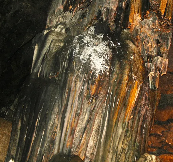
Indian karst caves are a mapping favourite: the Borra Caves in the Ananthagiri hills of the Eastern Ghats and the Belum Caves in Kurnool district (both Andhra Pradesh), the long caves of the Meghalaya plateau (Krem Liat Prah–Umim–Labit in the Jaintia Hills is among the longest known caves in India).
Mains box: analysis and answer points
- (karst) Wind works best in dry lands with little vegetation, as in the Thar.
- Erosional landforms: deflation hollows, mushroom rocks (pedestal rocks undercut near the ground, where sand is thickest), yardangs (ridges along the wind direction) and inselbergs (isolated rock hills).
- Depositional landforms: sand dunes, including crescent-shaped barchans whose horns point downwind, long seif (longitudinal) dunes, and loess, thick fine dust deposited far away (the Loess Plateau of China).
- Likely next angle: Indian caves and lagoons on the map
Practice
Write an answer
In 150 words, explain the significance of Geomorphology with one recent example.
Flashcards (2)
Which way do a barchan's horns point?
Downwind.
Which lagoon lies behind a sand bar in
Odisha? Chilika.
Read more: related explainers
- Jet Streams: Subtropical Westerly and Tropical Easterly Jets, Rossby Waves and their Role in Indian Weather
- Earthquakes: Causes, Seismic Waves, Magnitude and Intensity, India's Seismic Zones and Preparedness (UPSC Notes)
- Volcanoes: How They Form, Types, Volcanic Landforms, World Distribution and India's Volcanoes
In the news
- 16 Oct 2026Neyveli, Tiruchirappalli and Atacama: Indian scientists identify Martian analogue sites
- 14 Oct 2026India to accede to the Southern Indian Ocean Fisheries Agreement (SIOFA)
- 13 Oct 2026IMD launches a map-based Decision Support System for cyclone and marine warnings
- 1 Oct 2026Auction launched for two offshore polymetallic nodule blocks in the Andaman Sea
 Next chapter · 3. Climatology →Climatology: Atmosphere and heat
Syllabus: GS-I · Salient features of world’s physical geography.